
Order Total (1 Item Items):
Shipping Destination:

Bristol 1902 Gloucestershire Sheet by Bone Mike (22 results)
Skip to main search results
Product Type
- All Product Types
- Books (13)
- Magazines & Periodicals
- Comics
- Sheet Music
- Art, Prints & Posters
- Photographs
- Maps (9)
-
Manuscripts &
Paper Collectibles
Condition
Binding
- All Bindings
- Hardcover
- Softcover (5)
Collectible Attributes
- First Edition
- Signed
- Dust Jacket
- Seller-Supplied Images (1)
- Not Printed On Demand
Free Shipping
Seller Location
Seller Rating
-

Bristol (St.George) 1902: Gloucestershire Sheet 72.14 (Old O.S. Maps of Gloucestershire)
Published by Alan Godfrey Maps, 2002
ISBN 10: 1841514241ISBN 13: 9781841514246
Map
No Binding. Condition: As New. Like New. It is in excellent condition. The book is from library of former Western Mail journalist, Clive Betts. Fel newydd. Mae'r llyfr mewn cyflwr gwych. Mae'r llyfr yn dod o cyn lyfrgell newyddiadurwr Western Mail, Clive Betts.
-
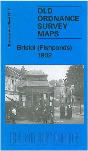
Bristol (Fishponds) 1902: Gloucestershire Sheet 72.10 (Old Ordnance Survey Maps of Gloucestershire)
Published by Alan Godfrey Maps, 1777
ISBN 10: 1847846297ISBN 13: 9781847846297
Book
Paperback. Condition: Very Good. The book has been read, but is in excellent condition. Pages are intact and not marred by notes or highlighting. The spine remains undamaged.
-
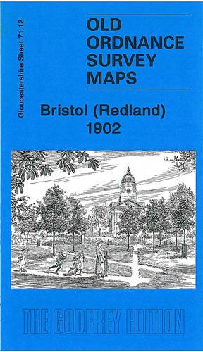
Bristol (Redland) 1902: Gloucestershire Sheet 71.12 (Old Ordnance Survey Maps of Gloucestershire)
Published by Alan Godfrey Maps, 2010
ISBN 10: 1847843581ISBN 13: 9781847843586
Book
Paperback. Condition: Very Good. The book has been read, but is in excellent condition. Pages are intact and not marred by notes or highlighting. The spine remains undamaged.
-
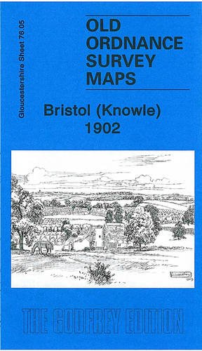
Bristol (Knowle) 1902: Gloucestershire Sheet 76.05 (Old Ordnance Survey Maps of Gloucestershire)
Published by Alan Godfrey Maps, 2009
ISBN 10: 1847842259ISBN 13: 9781847842251
Book
Paperback. Condition: Very Good. The book has been read, but is in excellent condition. Pages are intact and not marred by notes or highlighting. The spine remains undamaged.
-
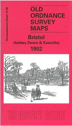
Bristol (Ashley Down and Eastville) 1902: Gloucestershire Sheet 72.09 (Old O.S. Maps of Gloucestershire)
Published by Alan Godfrey Maps, 2002
ISBN 10: 1841513954ISBN 13: 9781841513959
Book
Paperback. Condition: Fair. A readable copy of the book which may include some defects such as highlighting and notes. Cover and pages may be creased and show discolouration.
-
Bristol StGeorge 1902 Gloucestershire Sheet 7214 Old OS Maps of Gloucestershire
Published by Alan Godfrey Maps, 2002
ISBN 10: 1841514241ISBN 13: 9781841514246
Book
UNK. Condition: New. New Book. Shipped from UK. Established seller since 2000.
-
Bristol (St.George) 1902: Gloucestershire Sheet 72.14 (Old O.S. Maps of Gloucestershire)
Published by Alan Godfrey Maps, United Kingdom, Co Durham, 2002
ISBN 10: 1841514241ISBN 13: 9781841514246
Book
Paperback. Condition: Very Good. The book has been read, but is in excellent condition. Pages are intact and not marred by notes or highlighting. The spine remains undamaged.
-
Bristol (St.George) 1902: Gloucestershire Sheet 72.14 (Old O.S. Maps of Gloucestershire)
Published by Alan Godfrey Maps, 2002
ISBN 10: 1841514241ISBN 13: 9781841514246
Book
Map. Condition: New. BRAND NEW ** SUPER FAST SHIPPING FROM UK WAREHOUSE ** 30 DAY MONEY BACK GUARANTEE.
-
Bristol (St.George) 1902: Gloucestershire Sheet 72.14
Published by Alan Godfrey Maps, 2002
ISBN 10: 1841514241ISBN 13: 9781841514246
Book
Sheet map, folded. Condition: New. New copy - Usually dispatched within 4 working days.
-
Bristol (St.George) 1902: Gloucestershire Sheet 72.14 (Old O.S. Maps of Gloucestershire)
Published by Alan Godfrey Maps, 2002
ISBN 10: 1841514241ISBN 13: 9781841514246
Book
Condition: New. In.
-
Bristol (St.George) 1902: Gloucestershire Sheet 72.14 (Old O.S. Maps of Gloucestershire)
Published by Alan Godfrey Maps, 2002
ISBN 10: 1841514241ISBN 13: 9781841514246
Book
Condition: New. 2002. Facsimile. Map. Series: Old O.S. Maps of Gloucestershire. BIC Classification: 1DBKEWS; 3JJC; WQH; WTRM. Category: (G) General (US: Trade). Dimension: 210 x 120 x 2. Weight in Grams: 26. Gloucestershire Sheet 72.14. Series: Old O.S. Maps of Gloucestershire. Cateogry: (G) General (US: Trade). BIC Classification: 1DBKEWS; 3JJC; WQH; WTRM. Dimension: 210 x 120 x 2. Weight: 26. . . . . . Books ship from the US and Ireland.
-
Bristol (St.George) 1902: Gloucestershire Sheet 72.14 (Old O.S. Maps of Gloucestershire)
Published by Alan Godfrey Maps, 2002
ISBN 10: 1841514241ISBN 13: 9781841514246
Book
Condition: New. 2002. Facsimile. Map. Series: Old O.S. Maps of Gloucestershire. BIC Classification: 1DBKEWS; 3JJC; WQH; WTRM. Category: (G) General (US: Trade). Dimension: 210 x 120 x 2. Weight in Grams: 26. Gloucestershire Sheet 72.14. Series: Old O.S. Maps of Gloucestershire. Cateogry: (G) General (US: Trade). BIC Classification: 1DBKEWS; 3JJC; WQH; WTRM. Dimension: 210 x 120 x 2. Weight: 26. . . . . .
-
Bristol StGeorge 1902 Gloucestershire Sheet 7214 Old OS Maps of Gloucestershire
Published by Alan Godfrey Maps, 2002
ISBN 10: 1841514241ISBN 13: 9781841514246
Book
UNK. Condition: New. New Book. Shipped from UK. Established seller since 2000.
-
Bristol (St.George) 1902 : Gloucestershire Sheet 72.14
Published by Alan Godfrey Maps Jul 2002, 2002
ISBN 10: 1841514241ISBN 13: 9781841514246
Book
Karte. Condition: Neu. Neuware Deutsch.
-
Bristol (Knowle) 1902: Gloucestershire Sheet 76.05
Published by Alan Godfrey Maps, 2009
ISBN 10: 1847842259ISBN 13: 9781847842251
Map
No Binding. Condition: New. No Jacket. Here are the details of maps for Knowle: Gloucestershire Sheet 76.05 Knowle 1902 - published 2009; intro by Mike Bone. ISBN.978-1-84784-225-1 This detailed map covers most of the village of Knowle, south of Bristol. Coverage stretches from Somerset Road southward to Hengrove House, and from Lower Knowle Farm eastward to West Town Farm. Features include Brislington station, Queen's Dale Farm, Firfield House, Racecourse Cottages, St Martin's church, House of Charity, Lower Knowle, Bear's Bridge, Kingshill House, western edge of Brislington. On the reverse we include a street directory for Wells Road, plus railway timetables for the Bristol-Radstock-Frome line in 1906 and 1929. The map links up with sheet 75.08 Bedminster Down to the west, 76.01 Knowle to the north and 76.06 Brislington to the east.
-
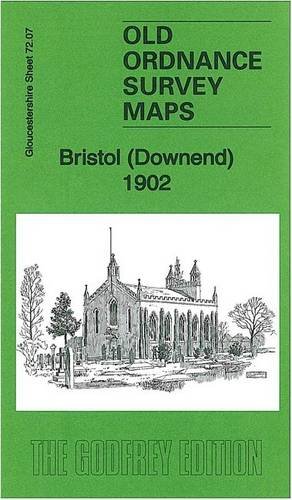
Bristol (Downend) 1902: Gloucestershire Sheet 72.07 (Old Ordnance Survey Maps of Gloucestershire)
Published by Alan Godfrey Maps, 2013
ISBN 10: 1847847404ISBN 13: 9781847847409
Map
No Binding. Condition: New. No Jacket. Here are the details of maps for Bristol Downend: Gloucestershire Sheet 72.07 Bristol (Downend) 1902 - published 2013; intro by Mike Bone. ISBN.978-1-84784-740-9 This detailed map covers the village of Downend, NE of Bristol, with a portion of Mangotsfield in the SE corner. Features include village centre with individual buildings neatly shown, Cleve Lodge, Clevehill, Clevehill Farm, Horseshoe pub, Christ Church, Overnhill House, Overndale, small portion of Frenchay, Stockwell Hill, Windsor Place, Crown pub, St James Street area of Mangotsfield. An 1894 directory of Downend is included on the reverse. The map links up with sheets 72.06 Frenchay to the west, 72.11 Staple Hill to the south.
-
Bristol (Ashley Down and Eastville) 1902: Gloucestershire Sheet 72.09 (Old O.S. Maps of Gloucestershire)
Published by Alan Godfrey Maps, 2002
ISBN 10: 1841513954ISBN 13: 9781841513959
Map
No Binding. Condition: New. No Jacket. Here are the details of maps for Bristol Eastville: Gloucestershire Sheet 72.09 Bristol (Ashley Down & Eastville) 1902 - published 2002; intro by Mike Bone. ISBN.978-1-84151-395-4 This detailed map covers the Eastville and Ashley Down areas on the north side of Bristol. Coverage stretches from Montpelier station eastward to Greenbank Cemtery, and northward to Dongola Avenue. A small portion of Stapleton, with Holy Trinity church and Colston's School is in the NE corner. Other features include Workhouse, football ground, Stapleton Gas Works, Midland Brick Works, stretch of Midland Railway Clifton Extension, stretch of GWR railway with Ashleyhill station, St Werburgh's church, New Orphan Houses, County cricket ground, St Andrew's Park, Ashleyhill Junction, Mina Road Park etc. On the reverse we include a directory for Stapleton and street directory entries for Ashley Down Road, Ashley Hill, Cobourg Road, Chesterfield Road, Eastville, Kensington Avenue, Robertson Road. The map links up with sheets 72.05 Horfield to the north, 71.12 Redland to the west, 72.10 Fishponds to the east and 72.13 Bristol NE to the south.
-
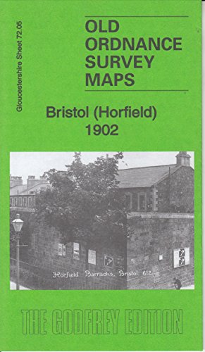
Bristol (Horfield) 1902: Gloucestershire Sheet 72.05 (Old Ordnance Survey Maps of Gloucestershire)
Published by Alan Godfrey Maps, 2016
ISBN 10: 1847849512ISBN 13: 9781847849519
Map
No Binding. Condition: New. No Jacket. Here are the details of maps for Bristol Horfield: Gloucs Sheet 72.05 Bristol (Horfield) 1902 - published 2016; intro by Mike Bone. ISBN.978-1-84784-951-9 This detailed map covers parts of Horfield and Stapleton Park, north of Bristol. Features include Stapleton Park, Stoke Park, Purdown Farm, Horfield Barracks, tramway, tram depot, Horfield Court Farm, Manor Farm, Wellington Hotel etc. Directories of Stapleton and Horfield are included on the reverse. The map links up with sheets 71.08 Westbury to the west, 72.06 Frenchay to the east, 72.09 Ashley Down to the south.
-
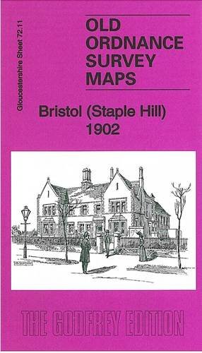
Bristol (Staple Hill) 1902: Gloucestershire Sheet 72.11
Published by Alan Godfrey Maps, 2012
ISBN 10: 1847845835ISBN 13: 9781847845832
Map
No Binding. Condition: New. No Jacket. Here are the details of maps for Soundwell: Gloucestershire Sheet 72.11 Bristol (Staple Hill) 1902 - published 2012; intro by Mike Bone. ISBN.978-1-84784-583-2 This detailed map covers the Staple Hill and Soundwell area of Bristol, and part of north Kingswood. Coverage stretches from Thicket Road eastward to Rodway Hill, and from High Street and Broad Street southward to Cockshot Hill. Features include tramway with depot, Midland Railway with Staple Hill and part of Mangotsfield stations (the latter at the east margin of map), Rodwayhill House, Sistonhill Farm, Hopewell Hill area, Leicester Square area, Lower Soundwell area, Upper Soundwell area, Staple Hill, Kingswood Lodge etc. On the reverse we include 1896 directory entries for Downend and Mangotsfield. The map links up with sheets 72.07 Downend to the north, 72.10 Fishponds to the west and 72.15 Kingswood to the south.
-
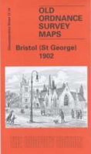
Bristol (St.George) 1902: Gloucestershire Sheet 72.14 (Old O.S. Maps of Gloucestershire)
Published by Alan Godfrey Maps, 2002
ISBN 10: 1841514241ISBN 13: 9781841514246
Map
No Binding. Condition: New. No Jacket. Here are the details of maps for Bristol St George's: Gloucestershire Sheet 72.14 Bristol (St George) 1902 - published 2006; intro by Mike Bone. ISBN.978-1-84151-424-6 This detailed map covers the St George's area east of Bristol, with coverage stretching from Blackwarth Road and Cossham Road eastward to Charlton Road and St Michael's church. Features include Twomile Hill, Meg Thatcher's Green, Whiteshill Farm, tramways, Crew's Hole, Troopers' Hill, White's Hill, Air Balloon Hill, Summer Hill, Bell Hill, Whiteway, Speedwell, Speedwell Pit, Hudds Bottom, Crofts End, St Aidan's church, Belgium pit (disused), Burchells Green, Blackswarth Lead Works, Avon View Cemetery, St George's Park, soap works, Whitehall Colliery, Rose Green etc. On the reverse we include directories for St George and Two Mile Hill. The map links up with sheets 72.10 Fishponds to the north, 72.13 Bristol NE to the west, 72.15 Kingswood to the east, 76.02 St Anne's Park to the south.
-
Bristol (Fishponds) 1902: Gloucestershire Sheet 72.10 (Old Ordnance Survey Maps of Gloucestershire)
Published by Alan Godfrey Maps, 2012
ISBN 10: 1847846297ISBN 13: 9781847846297
Map
No Binding. Condition: New. No Jacket. Here are the details of maps for Bristol Fishponds: Gloucestershire Sheet 72.10 Bristol (Fishponds) 1902 - published 2012; intro by Mike Bone. ISBN.978-1-84784-629-7 This detailed map covers the Fishponds, Ridgeway, Upper Eastville and Mayfield Park areas of Bristol. Features include tramways, Midland Railway with Stapleton (later Fishponds) station, Kingswood Junction, Hollybrook Brick Works, Chester Park area, Atlas Locomotive Works, Weighing Machine Works, Clay Hill, brick works, Greenbank Cemetery, St Mary's church, St John's Mission Church, Ridgeway Park Cemetery, Ridgeway House, part of Eastville Park, Clay Bottom etc. An 1894 directory of Fishponds is included on the reverse. The map links up with sheets 72.06 Frenchay to the north, 72.09 Ashley Down to the west, 72.11 Staple Hill to the east, 72.14 St Georges to the south.
-
Bristol (Redland) 1902: Gloucestershire Sheet 71.12
Published by Alan Godfrey Maps, 2010
ISBN 10: 1847843581ISBN 13: 9781847843586
Map
No Binding. Condition: New. No Jacket. Here are the details of maps for Redland: Gloucestershire Sheet 71.12 Bristol (Redland) 1902 - published 2010; intro by Mike Bone. ISBN.978-1-84784-358-6 This detailed map covers a busy area of NW Bristol, including much of Redland, Westbury Park, and Bishopston. Coverage stretches from Durham Down eastward to Effingham Road, and from Chandos Road northward to Bishop Road. Features include Redland area, Bishopston area, Westbury Park area, Woolcott Park area, Clifton Extension Railway with Redland station, tramways, Redland Chapel, Redland Green, St John's church, Redlandhill House, New Clifton area, Downside, St Alban's church, Colstan's School, St Katharine's church, St Bonaventure's RC church, Redland Court school, Queen Victoria Convalescent Home, etc. On the reverse we include street directoriy entries for Berkeley Road, Clarendon Road, Clyde Park/Road, Egerton Road, Elgin Park, Elliston Road, Redland Grove/Hill/Park Villa/Road/Terrace, Woodstock Road. The map links up with sheets 71.08 Westbury-on-Trym to the north, 71.11 Sneyd Park to the west, 72.09 Ashley Down to the east, 71.16 Bristol NW to the south.