Liverpool (Mount Pleasant) 1848: Liverpool Sheet 30 (Old Ordnance Survey Maps)
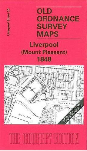

Here are the details of maps for Liverpool Mount Pleasant: Liverpool Sheet 30 Liverpool (Mount Pleasant) 1848 - published 2005; intro by Kay Parrott. ISBN.978-1-84151-811-4 This wonderfully detailed map covers the area of Liverpool around Mount Pleasant. Coverage stretches from Bold Street and Wood Street eastward to Abercromby Square, and from Brownlow Hill southward to Hope Place. The many features include Parish Workhouse, St Mary's Cemetery, fever hospital, St Philip's church, Rodney St Presbyterian Chapel, St Luke's church, Royal Institution, Ranelagh Place, Adelphi Hotel, and the many streets, courts, passages and even gardens in the adjacent area. We include a selection of street directory entries on the reverse, including Bedford Street, Brownlow Hill, Mount Pleasant, Mulberry Street, Renshaw Street, Rodney Street, Seel Street. The map links up with Liverpool Sheets 25 Liverpool London Road to the north, 29 Hanover Street to the west and 35 Liverpool St James' Mount to the south.
"synopsis" may belong to another edition of this title.
- PublisherAlan Godfrey Maps
- Publication date2005
- ISBN 10 1841518115
- ISBN 13 9781841518114
- BindingMap
Buy New
Learn more about this copy
US$ 3.53
Shipping:
US$ 37.94
From United Kingdom to U.S.A.
Top Search Results from the AbeBooks Marketplace
Stock Image
Liverpool (Mount Pleasant) 1848: Liverpool Sheet 30
Seller:
Rating
Book Description No Binding. Condition: New. No Jacket. Here are the details of maps for Liverpool Mount Pleasant: Liverpool Sheet 30 Liverpool (Mount Pleasant) 1848 - published 2005; intro by Kay Parrott. ISBN.978-1-84151-811-4 This wonderfully detailed map covers the area of Liverpool around Mount Pleasant. Coverage stretches from Bold Street and Wood Street eastward to Abercromby Square, and from Brownlow Hill southward to Hope Place. The many features include Parish Workhouse, St Mary's Cemetery, fever hospital, St Philip's church, Rodney St Presbyterian Chapel, St Luke's church, Royal Institution, Ranelagh Place, Adelphi Hotel, and the many streets, courts, passages and even gardens in the adjacent area. We include a selection of street directory entries on the reverse, including Bedford Street, Brownlow Hill, Mount Pleasant, Mulberry Street, Renshaw Street, Rodney Street, Seel Street. The map links up with Liverpool Sheets 25 Liverpool London Road to the north, 29 Hanover Street to the west and 35 Liverpool St James' Mount to the south. Seller Inventory # 000748
Buy New
US$ 3.53
Convert currency