Order Total (1 Item Items):
Shipping Destination:

Standard Map Company (42 results)
Skip to main search results
Product Type
- All Product Types
- Books (42)
- Magazines & Periodicals
- Comics
- Sheet Music
- Art, Prints & Posters
- Photographs
- Maps
-
Manuscripts &
Paper Collectibles
Condition
Binding
Collectible Attributes
- First Edition (2)
- Signed
- Dust Jacket
- Seller-Supplied Images (23)
- Not Printed On Demand (23)
Free Shipping
Seller Location
Seller Rating
-

Life in Colonial America and the Westward Expansion of the United States
Published by Esso Standard Oil Company, New York, 1952
Book First Edition
Soft cover. Condition: Fair. Dust Jacket Condition: No Dustjacket. Map (illustrator). First Edition. This is a fold out map. The map cover piece has some wear and a tiny amount of paper loss in two areas. It is a full color map of Life in Colonial America and the Westward Expansion of the United States. Email us for a picture, we ship fast. Size: Thin.
-

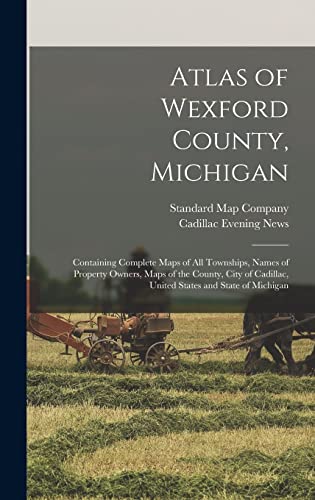
Atlas of Wexford County, Michigan: Containing Complete Maps of All Townships, Names of Property Owners, Maps of the County, City of Cadillac, United S (Paperback or Softback)
Published by Legare Street Press 9/10/2021, 2021
ISBN 10: 1014938708ISBN 13: 9781014938701
Book
Paperback or Softback. Condition: New. Atlas of Wexford County, Michigan: Containing Complete Maps of All Townships, Names of Property Owners, Maps of the County, City of Cadillac, United S 0.19. Book.
More buying choices from other sellers on AbeBooks
New offers from US$ 16.67
-
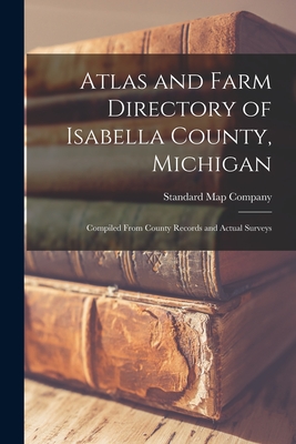
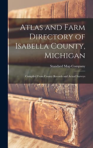
Atlas and Farm Directory of Isabella County, Michigan: Compiled From County Records and Actual Surveys (Paperback or Softback)
Published by Legare Street Press 9/9/2021, 2021
ISBN 10: 1013857348ISBN 13: 9781013857348
Book
Paperback or Softback. Condition: New. Atlas and Farm Directory of Isabella County, Michigan: Compiled From County Records and Actual Surveys 0.17. Book.
More buying choices from other sellers on AbeBooks
New offers from US$ 16.73
-
![Seller image for The county of Bay : state, county, township, city and village maps [LeatherBound] for sale by True World of Books](https://pictures.abebooks.com/inventory/md/md31534670539.jpg)
The county of Bay : state, county, township, city and village maps [LeatherBound]
Publication Date: 2023
Book Print on Demand
LeatherBound. Condition: New. LeatherBound edition. Condition: New. Reprinted from 1916 edition. Leather Binding on Spine and Corners with Golden leaf printing on spine. Bound in genuine leather with Satin ribbon page markers and Spine with raised gilt bands. A perfect gift for your loved ones. NO changes have been made to the original text. This is NOT a retyped or an ocr'd reprint. Illustrations, Index, if any, are included in black and white. Each page is checked manually before printing. As this print on demand book is reprinted from a very old book, there could be some missing or flawed pages, but we always try to make the book as complete as possible. Fold-outs, if any, are not part of the book. If the original book was published in multiple volumes then this reprint is of only one volume, not the whole set. Sewing binding for longer life, where the book block is actually sewn (smythe sewn/section sewn) with thread before binding which results in a more durable type of binding. Pages: 68 Language: English.
-
![Seller image for Atlas and farm directory of Isabella County, Michigan : compiled from county records and actual surveys (1915) [LeatherBound] for sale by True World of Books](https://pictures.abebooks.com/inventory/md/md31618478262.jpg)
LeatherBound. Condition: New. LeatherBound edition. Condition: New. Reprinted from 1915 edition. Leather Binding on Spine and Corners with Golden leaf printing on spine. Bound in genuine leather with Satin ribbon page markers and Spine with raised gilt bands. A perfect gift for your loved ones. NO changes have been made to the original text. This is NOT a retyped or an ocr'd reprint. Illustrations, Index, if any, are included in black and white. Each page is checked manually before printing. As this print on demand book is reprinted from a very old book, there could be some missing or flawed pages, but we always try to make the book as complete as possible. Fold-outs, if any, are not part of the book. If the original book was published in multiple volumes then this reprint is of only one volume, not the whole set. Sewing binding for longer life, where the book block is actually sewn (smythe sewn/section sewn) with thread before binding which results in a more durable type of binding. Pages: 44.
-
![Seller image for Atlas of Wexford County, Michigan : containing complete maps of all townships, names of property owners, maps of the county, city of Cadillac, United States and State of Michigan (1914) [LeatherBound] for sale by True World of Books](https://pictures.abebooks.com/inventory/md/md31657347313.jpg)
LeatherBound. Condition: New. LeatherBound edition. Condition: New. Reprinted from 1914 edition. Leather Binding on Spine and Corners with Golden leaf printing on spine. Bound in genuine leather with Satin ribbon page markers and Spine with raised gilt bands. A perfect gift for your loved ones. NO changes have been made to the original text. This is NOT a retyped or an ocr'd reprint. Illustrations, Index, if any, are included in black and white. Each page is checked manually before printing. As this print on demand book is reprinted from a very old book, there could be some missing or flawed pages, but we always try to make the book as complete as possible. Fold-outs, if any, are not part of the book. If the original book was published in multiple volumes then this reprint is of only one volume, not the whole set. Sewing binding for longer life, where the book block is actually sewn (smythe sewn/section sewn) with thread before binding which results in a more durable type of binding. Pages: 50 Standard Map Company,Cadillac Evening News (Firm).
-
Atlas and Farm Directory of Isabella County, Michigan
Published by Legare Street Press, 2021
ISBN 10: 1013379721ISBN 13: 9781013379727
Book Print on Demand
HRD. Condition: New. New Book. Shipped from UK. THIS BOOK IS PRINTED ON DEMAND. Established seller since 2000.
More buying choices from other sellers on AbeBooks
New offers from US$ 33.81
-
Atlas of Wexford County, Michigan
Published by LIGHTNING SOURCE UK LTD, 2021
ISBN 10: 1013763637ISBN 13: 9781013763632
Book Print on Demand
HRD. Condition: New. New Book. Shipped from UK. THIS BOOK IS PRINTED ON DEMAND. Established seller since 2000.
More buying choices from other sellers on AbeBooks
New offers from US$ 33.86
-
MIDGET ROAD MAP OF NEW YORK Belmont Cafeteria-123 Lake Street-Elmira, NY
Published by ***** Self Published ***** 1924-5, Chicago, IL, 1924
Seller: Riverow Bookshop, Owego, NY, U.S.A.
Seller Rating:

Wraps. Condition: VG/No Dustjacket. Maps (illustrator). Chicago, IL: ***** Self Published *****. VG/No Dustjacket. 1924-5. . Wraps. Advertises the Belmont Cafeteria, Elmira, N.Y. . miniature, 1 folded map, Cover for map is rubbed & bent; map is in vg condidion .
-

Topographical Map of Ontonagon County Michigan - Detailed map of Ontonagon County, Michigan.
Published by c. 1927, 1927
Seller: Curtis Wright Maps, Berwyn, IL, U.S.A.
Seller Rating:

Condition: Fine. The extensive hydrological system of Ontonagon County is evident on this map, published in Chicago by the Standard Map Company. Rivers and streams greatly outnumber the listed highways, railroads, and trunk lines that serve the isolated area in Michigan's Upper Peninsula. Sections are numbered individually and the location of schools are noted within each labeled township. Sheet Width (in) 19 Sheet Height (in) 19.5 Condition Description Minor creasing and wear along fold lines. Slight smudging in the upper right corner and in a few scattered spots throughout the image. Minor discoloration, manuscript ink writing, and a rubber stamp dated 1927 on the verso.
-
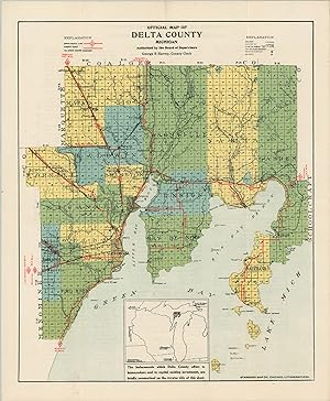
Offical Map of Delta County, Michigan - Hybrid promotional flyer and transportation map of a county in Michigan's Upper Peninsula.
Published by c. 1927, 1927
Seller: Curtis Wright Maps, Berwyn, IL, U.S.A.
Seller Rating:
Condition: Fine. This brightly colored, late 1920's road map vividly highlights the network of county roads and state trunk lines available in Delta County, Michigan. Both are shown in red, with distances to nearby destinations noted in the white space around the image. Other local routes (presumably gravel or dirt) and railroads are represented in black. At the bottom, an inset map notes Delta County's location (and triangular shape) in the Upper Peninsula. The verso features 'a few facts about Delta County of interest to homeseekers, capitalists, and manufacturers.' These include wealthy banks, seasonal tourists, rich soil, a healthy climate, and a robust transportation network. The map was designed by George Harvey and authorized by the Delta County Board of Supervisors. Lithographed in Chicago by the Standard Map Company. Sheet Width (in) 14 Sheet Height (in) 17 Condition Description Creasing and minor wear along fold lines. Faint discoloration, an old rubber stamp dated 1927, and ink script on the verso.
-
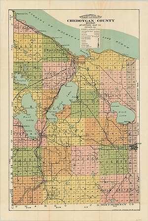
Topographical Map of Cheboygan County Michigan - Vibrantly lithographed map of Cheboygan County published near the end of the first quarter of the 20th century.
Published by c. 1926, 1926
Seller: Curtis Wright Maps, Berwyn, IL, U.S.A.
Seller Rating:
Condition: Fine. Despite being titled a topographical map, physical features are notably absent on this image of Cheboygan County, Michigan, published by the Standard Map Company in Chicago around 1926. Bright colors distinguish various local townships, while a variety of symbols (outlined in the accompanying legend) note schools, churches, cemeteries, state parks, and golf courses. Main traveled roads, highways, and railroads are also identified. Blank on verso. Sheet Width (in) 13.6 Sheet Height (in) 20.25 Condition Description "Creasing and a few small areas of faint discoloration along fold lines. One small 2" tear on the right side has been repaired on the verso.".
-
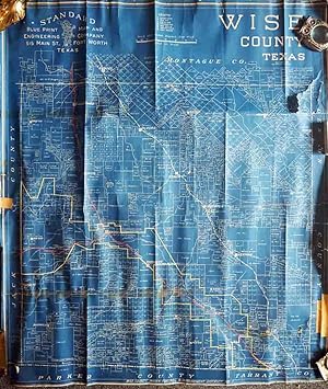
Wise County, Texas
Published by Fort Worth c.1950, Fort Worth, 1950
Seller: High Ridge Books, Inc. - ABAA, South Deerfield, MA, U.S.A.
Association Member: ABAA ESA ILAB SNEAB
Seller Rating:
Unbacked blueprint-style map of this county northwest of Ft. Worth. Fair condition, with some loss at the right side and bottom right corner. Crude tape repairs to one long horizontal tear on the front and other tears on the verso. One railroad and some town boundaries outlined in color. The key at the top defines the symbols used for various oil drilling sites, whether producing, drilling, a dry hole or abandoned.
-
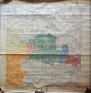
Jack County, Texas
Published by Fort Worth c.1950, Fort Worth, 1950
Seller: High Ridge Books, Inc. - ABAA, South Deerfield, MA, U.S.A.
Association Member: ABAA ESA ILAB SNEAB
Seller Rating:
Unbacked map of this county between Fort Worth and Wichita Falls. Good condition, several tears with light damage near the lower edge with no loss. Manuscript full color denotes school districts. Hundreds of large land owners identified. From the archives of the Rock Island Railroad.
-
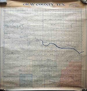
Gary County, Texas
Published by Fort Worth c.1950, Fort Worth, 1950
Seller: High Ridge Books, Inc. - ABAA, South Deerfield, MA, U.S.A.
Association Member: ABAA ESA ILAB SNEAB
Seller Rating:
Unbacked map of this county in the Texas panhandle east of Amarillo. Excellent condtion. Some areas have manuscript full color. The line of the Santa Fe Railroad is also highlighted in color. Land owners and drilling rights holders identified.The key at the top defines the symbols used for various oil drilling sites, whether producing, drilling, a dry hole or abandoned.
-
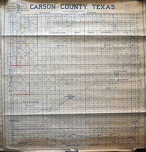
Carson County, Texas
Published by Fort Worth c.1950, Fort Worth, 1950
Seller: High Ridge Books, Inc. - ABAA, South Deerfield, MA, U.S.A.
Association Member: ABAA ESA ILAB SNEAB
Seller Rating:
Unbacked map of this county in the Texas panhandle east of Amarillo. Excellent condtion. Some areas have manuscript outline color. Land owners and drilling rights holders identified.The key at the top defines the symbols used for various oil drilling sites, whether producing, drilling, a dry hole or abandoned.
-
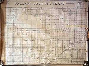
Dallam County, Texas
Published by Fort Worth c.1950, Fort Worth, 1950
Seller: High Ridge Books, Inc. - ABAA, South Deerfield, MA, U.S.A.
Association Member: ABAA ESA ILAB SNEAB
Seller Rating:
Unbacked map of this county at the northwest corner of the Texas panhandle. Some large land owners are identified as are some lands within the control of railroads. Two rail lines are highlighted with color. The key at the top left defines the symbols used for various oil drilling sites, whether producing, drilling, a dry hole or abandoned.
-
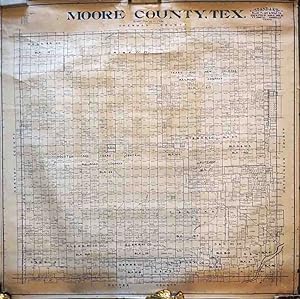
Moore County, Texas
Published by Fort Worth c.1950, Fort Worth, 1950
Seller: High Ridge Books, Inc. - ABAA, South Deerfield, MA, U.S.A.
Association Member: ABAA ESA ILAB SNEAB
Seller Rating:
Unbacked map of this county north of Amarillo in the Texas panhandle. Good condition, with some deterioration at edges. Land owners and drilling rights holders identified.The key at the top defines the symbols used for various oil drilling sites, whether producing, drilling, a dry hole or abandoned.
-
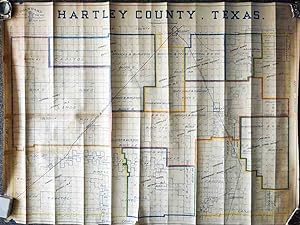
Hartley County, Texas
Published by Fort Worth c.1950, Fort Worth, 1950
Seller: High Ridge Books, Inc. - ABAA, South Deerfield, MA, U.S.A.
Association Member: ABAA ESA ILAB SNEAB
Seller Rating:
Unbacked map of this county at the west side of the Texas panhandle on the New Mexico border. Very good condition, one short tear at the bottom. Vertical creasing. Some areas have manuscript outline color. Land owners and drilling rights holders identified.The key at the top defines the symbols used for various oil drilling sites, whether producing, drilling, a dry hole or abandoned.
-
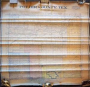
Potter County, Texas
Published by Fort Worth c.1950, Fort Worth, 1950
Seller: High Ridge Books, Inc. - ABAA, South Deerfield, MA, U.S.A.
Association Member: ABAA ESA ILAB SNEAB
Seller Rating:
Unbacked map of this county containing the city of Amarillo in the Texas panhandle. Good condition, with some tears and horizontal creasing. Some areas have manuscript color. Land owners and drilling rights holders identified.The key at the top defines the symbols used for various oil drilling sites, whether producing, drilling, a dry hole or abandoned.
-
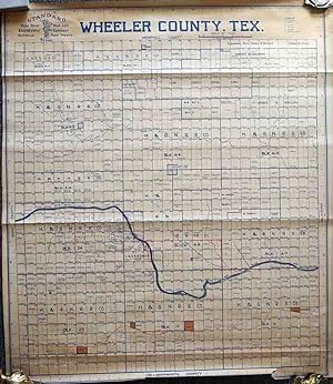
Wheeler County, Texas
Published by Fort Worth c.1950, Fort Worth, 1950
Seller: High Ridge Books, Inc. - ABAA, South Deerfield, MA, U.S.A.
Association Member: ABAA ESA ILAB SNEAB
Seller Rating:
Unbacked map of this county at the east side of the Texas panhandle between Amarillo and Oklahoma City. Very good condition, one short tear at the bottom. Some areas have manuscript color. Land owners holders identified.The key at the top defines the symbols used for various oil drilling sites, whether producing, drilling, a dry hole or abandoned.
-
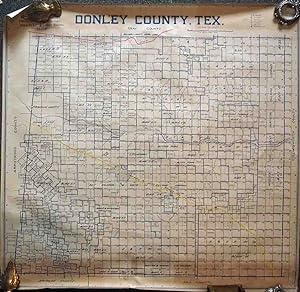
Donley County, Texas
Published by Fort Worth c.1950, Fort Worth, 1950
Seller: High Ridge Books, Inc. - ABAA, South Deerfield, MA, U.S.A.
Association Member: ABAA ESA ILAB SNEAB
Seller Rating:
Unbacked map of this county east of Amarillo in the northern Texas panhandle. Hundreds of large land owners identified. Two features are in color. The line of the Fort Worth and Denver Railroad is highlighted in yellow, and the C. O. & G. (Choctaw, Oklahoma & Gulf) line runs near the top of the map . The key at the top right defines the symbols used for various oil drilling sites, whether producing, drilling, a dry hole or abandoned.
-
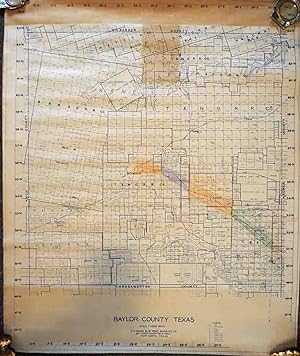
Baylor County, Texas
Published by Fort Worth c.1950, Fort Worth, 1950
Seller: High Ridge Books, Inc. - ABAA, South Deerfield, MA, U.S.A.
Association Member: ABAA ESA ILAB SNEAB
Seller Rating:
Unbacked map of this county in the northern Texas southwest of Wichita Falls. Hundreds of large land owners identified as are some lands within the control of railroads. Some manuscript color along rail lines. The key at the bottom defines the symbols used for various oil drilling sites, whether producing, drilling, a dry hole or abandoned.
-
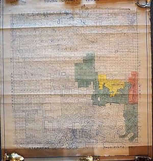
Young County, Texas
Published by Fort Worth c.1950, Fort Worth, 1950
Seller: High Ridge Books, Inc. - ABAA, South Deerfield, MA, U.S.A.
Association Member: ABAA ESA ILAB SNEAB
Seller Rating:
Unbacked map of this county west of Fort Worth and south of WIchita Falls. Good to very good condition, with some tears and deterioration at the top. Some areas have manuscript color. Land owners and drilling rights holders identified.The key at the top defines the symbols used for various oil drilling sites, whether producing, drilling, a dry hole or abandoned.
-
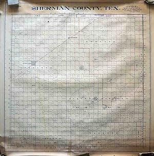
Sherman County, Texas
Published by Fort Worth c.1950, Fort Worth, 1950
Seller: High Ridge Books, Inc. - ABAA, South Deerfield, MA, U.S.A.
Association Member: ABAA ESA ILAB SNEAB
Seller Rating:
Unbacked map of this county on the northern boundary of the Texas panhandle. Excellent condtion. Some areas have manuscript outline color. Land owners and drilling rights holders identified.The key at the top defines the symbols used for various oil drilling sites, whether producing, drilling, a dry hole or abandoned.
-
Atlas and Farm Directory of Isabella County Michigan: Compiled from County Records and Actual Surveys
Published by Standard Map Co., Chicago, 1915
Seller: Elk River Books (ABAA/ILAB), Livingston, MT, U.S.A.
Association Member: ABAA ILAB IOBA RMABA
Seller Rating:
First Edition
Hardcover. Condition: Good. First Edition. Folio (40 cm), pp. 38. Black cloth with burgundy quarter leather. Colored, engraved maps of each Township (as well as the entire County and the State of Michigan) showing ownership of each plot of land greater than 20 acres. Each township has an accompanying chart of names of farmers, acreage owned, and notes on crops and livestock raised. These pages also have numerous advertisements for local businesses. At the top of each Township map, in neat pencil handwriting, is the name of the Township Supervisor in 1927. Boards are partly detached, with edge wear and rubbing, and pages show heavy soiling and foxing, though most map areas are in very good condition. The Michigan map has a couple of small holes at the border of the map, not affecting the land area.
-
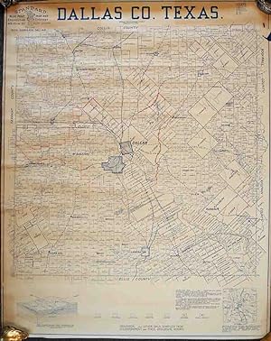
Dallas County
Published by Fort Worth & Dallas c.1950, Fort Worth & Dallas, 1950
Seller: High Ridge Books, Inc. - ABAA, South Deerfield, MA, U.S.A.
Association Member: ABAA ESA ILAB SNEAB
Seller Rating:
Large map of Dallas County printed in blue. One manuscript boundary line in red, otherwise excellent condition. Large land owners identified, including the Kleberg family around the town of Kleberg. A handful of oil well locations are also shown.