Order Total (1 Item Items):
Shipping Destination:

Jeffreys Thomas (29 results)
Skip to main search results
Product Type
- All Product Types
- Books (23)
- Magazines & Periodicals
- Comics
- Sheet Music
- Art, Prints & Posters (1)
- Photographs
- Maps (4)
- Manuscripts & Paper Collectibles (1)
Condition
Binding
Collectible Attributes
Free Shipping
Seller Location
Seller Rating
-
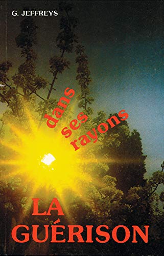
Dans ses rayons, la guérison
Published by VIENS ET VOIS, 1983
ISBN 10: 2902628218ISBN 13: 9782902628216
Book
Condition: good. Befriedigend/Good: Durchschnittlich erhaltenes Buch bzw. Schutzumschlag mit Gebrauchsspuren, aber vollständigen Seiten. / Describes the average WORN book or dust jacket that has all the pages present.
-

Review of Harold Jeffries [sic], The Earth, Its Origin, History and Physical Constitution by T C C.
Published by Offprint, 1924
Book
Pamphlet. Condition: Good. 20p review, old crease to cover, very good, name of reviewed author consistently mis-spelled throughout - now there is a howler Language: English.
-
Four folding maps in card folder with an introduction by Paul Hindle. In very good condition.
-
![Seller image for Remarks on the efficacy of matico, as a styptic and astringent : with additional cases, mode of exhibition, &c. [LeatherBound] for sale by True World of Books](https://pictures.abebooks.com/inventory/md/md31533720579.jpg)
LeatherBound. Condition: New. Leather Binding on Spine and Corners with Golden leaf printing on spine. Bound in genuine leather with Satin ribbon page markers and Spine with raised gilt bands. A perfect gift for your loved ones. Reprinted from 1845 edition. NO changes have been made to the original text. This is NOT a retyped or an ocr'd reprint. Illustrations, Index, if any, are included in black and white. Each page is checked manually before printing. As this print on demand book is reprinted from a very old book, there could be some missing or flawed pages, but we always try to make the book as complete as possible. Fold-outs, if any, are not part of the book. If the original book was published in multiple volumes then this reprint is of only one volume, not the whole set and contains approximately 48 pages. IF YOU WISH TO ORDER PARTICULAR VOLUME OR ALL THE VOLUMES YOU CAN CONTACT US. Resized as per current standards. Sewing binding for longer life, where the book block is actually sewn (smythe sewn/section sewn) with thread before binding which results in a more durable type of binding. Language: English.
-
![Seller image for Disputatio medica inauguralis de cynanche tracheali . (1804) [LeatherBound] for sale by True World of Books](https://pictures.abebooks.com/inventory/md/md31618509778.jpg)
Disputatio medica inauguralis de cynanche tracheali . (1804) [LeatherBound]
Publication Date: 2023
Book Print on Demand
LeatherBound. Condition: New. LeatherBound edition. Condition: New. Reprinted from 1804 edition. Leather Binding on Spine and Corners with Golden leaf printing on spine. Bound in genuine leather with Satin ribbon page markers and Spine with raised gilt bands. A perfect gift for your loved ones. NO changes have been made to the original text. This is NOT a retyped or an ocr'd reprint. Illustrations, Index, if any, are included in black and white. Each page is checked manually before printing. As this print on demand book is reprinted from a very old book, there could be some missing or flawed pages, but we always try to make the book as complete as possible. Fold-outs, if any, are not part of the book. If the original book was published in multiple volumes then this reprint is of only one volume, not the whole set. Sewing binding for longer life, where the book block is actually sewn (smythe sewn/section sewn) with thread before binding which results in a more durable type of binding. Pages: 72.
-
![Seller image for Remarks on the efficacy of matico, as a styptic and astringent. With additional cases, mode of exhibition, &c (1844) [LeatherBound] for sale by True World of Books](https://pictures.abebooks.com/inventory/md/md31618677473.jpg)
LeatherBound. Condition: New. LeatherBound edition. Condition: New. Reprinted from 1844 edition. Leather Binding on Spine and Corners with Golden leaf printing on spine. Bound in genuine leather with Satin ribbon page markers and Spine with raised gilt bands. A perfect gift for your loved ones. NO changes have been made to the original text. This is NOT a retyped or an ocr'd reprint. Illustrations, Index, if any, are included in black and white. Each page is checked manually before printing. As this print on demand book is reprinted from a very old book, there could be some missing or flawed pages, but we always try to make the book as complete as possible. Fold-outs, if any, are not part of the book. If the original book was published in multiple volumes then this reprint is of only one volume, not the whole set. Sewing binding for longer life, where the book block is actually sewn (smythe sewn/section sewn) with thread before binding which results in a more durable type of binding. Pages: 44.
-
![Seller image for An address to the Liverpool Medical Society, on being elected one of the Presidents : Read October 29, 1834 (1825) [LeatherBound] for sale by True World of Books](https://pictures.abebooks.com/inventory/md/md31657296135.jpg)
LeatherBound. Condition: New. LeatherBound edition. Condition: New. Reprinted from 1825 edition. Leather Binding on Spine and Corners with Golden leaf printing on spine. Bound in genuine leather with Satin ribbon page markers and Spine with raised gilt bands. A perfect gift for your loved ones. NO changes have been made to the original text. This is NOT a retyped or an ocr'd reprint. Illustrations, Index, if any, are included in black and white. Each page is checked manually before printing. As this print on demand book is reprinted from a very old book, there could be some missing or flawed pages, but we always try to make the book as complete as possible. Fold-outs, if any, are not part of the book. If the original book was published in multiple volumes then this reprint is of only one volume, not the whole set. Sewing binding for longer life, where the book block is actually sewn (smythe sewn/section sewn) with thread before binding which results in a more durable type of binding. Pages: 22.
-
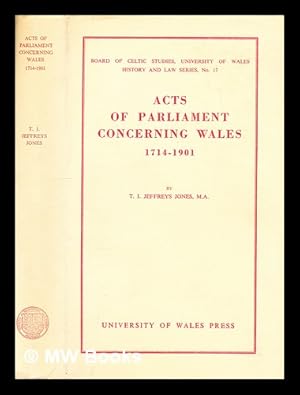
Acts of Parliament concerning Wales, 1714-1901
Published by Cardiff : University of Wales Press, 1966
2nd edition. Near fine cloth copy in a near-fine, very slightly edge-nicked and dust-dulled dust wrapper, now mylar-sleeved. Remains particularly well-preserved overall; tight, bright, clean and strong. Subjects: Great Britain Laws, statutes. Collections. 1 Kg.
-
Wales through the Ages: Volume I: From the Earliest Times to 1485. Volume II: Modern Wales.
Published by Christopher Davies (Publishers) 1959, 1971, Llandybie, Wales, 1959
200 / 216 pp. Good condition; touches of wear on covers.
-
![Seller image for The useful family herbal, or, An account of all those English plants, which are remarkable for their virtues ?and of the drugs, which are produced by vegetables of other countries ? with their descriptions, and their uses, as proved by experience ? illustrated with figures of the most useful English plants ? with an introduction . and an appendix containing a proposal for the farther seeking into the virtues of English herbs, and the manner of doing it with ease and safety ? the whole intended for the use of families, and for the instruction of those who are desirous of relieving the distressed sick /by John Hill . [LeatherBound] for sale by True World of Books](https://pictures.abebooks.com/inventory/md/md31533960342.jpg)
The useful family herbal, or, An account of all those English plants, which are remarkable for their virtues ?and of the drugs, which are produced by vegetables of other countries ? with their descriptions, and their uses, as proved by experience ? illustrated with figures of the most useful English plants ? with an introduction . and an appendix containing a proposal for the farther seeking into the virtues of English herbs, and the manner of doing it with ease and safety ? the whole intended for the use of families, and for the instruction of those who are desirous of relieving the distressed sick /by John Hill . [LeatherBound]
Publication Date: 2023
Book Print on Demand
LeatherBound. Condition: New. LeatherBound edition. Condition: New. Reprinted from 1755 edition. Leather Binding on Spine and Corners with Golden leaf printing on spine. Bound in genuine leather with Satin ribbon page markers and Spine with raised gilt bands. A perfect gift for your loved ones. NO changes have been made to the original text. This is NOT a retyped or an ocr'd reprint. Illustrations, Index, if any, are included in black and white. Each page is checked manually before printing. As this print on demand book is reprinted from a very old book, there could be some missing or flawed pages, but we always try to make the book as complete as possible. Fold-outs, if any, are not part of the book. If the original book was published in multiple volumes then this reprint is of only one volume, not the whole set. Sewing binding for longer life, where the book block is actually sewn (smythe sewn/section sewn) with thread before binding which results in a more durable type of binding. Pages: 469 Language: English.
-

Acts of Parliament concerning Wales, 1714-1901
Published by Cardiff : University of Wales Press, 1966
2nd edition. Near fine cloth copy in a near-fine, very slightly edge-nicked and dust-dulled dust wrapper, now mylar-sleeved. Remains particularly well-preserved overall; tight, bright, clean and strong. Subjects: Great Britain Laws, statutes. Collections. 1 Kg.
-
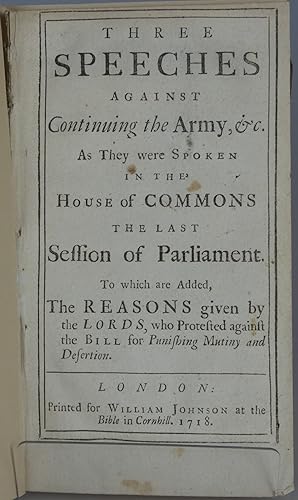
Three Speeches Against Continuing the Army, &c. As They Were Spoken in the house of Commons the Last Session of Parliament. To Which are Added, the Reasons Given by the Lords, Who Protested Against the Bill for Punishing Mutiny and Desertion
Published by William Johnson, London, 1718
Soft Cover. Condition: Good. Booklet, disbound, modern paper wraps. 46pp. Occasional small soiling. Scarce. (a0).
-
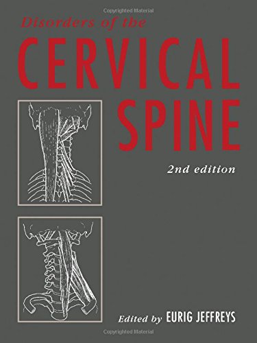
Disorders of the Cervical Spine
Published by Elsevier, 1993
ISBN 10: 0750613610ISBN 13: 9780750613613
Book
Condition: Used. pp. 240 5th Edition.
-
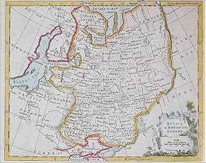
No Binding. Condition: Very Good. Jefferys, Thomas : Russia or Moscovy in Europe. ca.1749. Copper engraved map with hand coloured outline. Decorative cartouche with scale and engraver. Map shows modern day Russian Baltic area, Poland and northern Turkey. Size approx 230mm x 180mm, good margins, fold as issued. A clean and bright map of Eastern Europe and Russia in the 18th century.
-
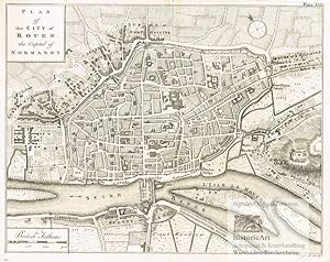
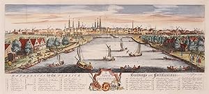
Plan of the City of Rouen the Capital of Normandy. Antique Map. Stadtplan von Rouen in der Normandie an der Seine. Original-Kupferstich von Thomas Jeffreys um 1770
Published by London: John Cary um, 1815
Seller: historicArt Antiquariat & Kunsthandlung, Wiesbaden-Breckenheim, Germany
Seller Rating:

Map First Edition Signed
1. detailreicher Original-Kupferstich von Thomas Jeffreys (in der Platte signiert) auf rückseitig unbedrucktem Büttenkarton, bildliche Darstellung ca. 20 x 25,5 cm, mit dekorativ abgesetztem Plattenrand, Blattgröße ca. 24,5 x 33 cm, rückseitig Namenseintrag des Vorbesitzers in Tinte, kleiner Einriss oben in der geglätteten Mittelfalz, im unteren breiten Rand etwas angestaubt, ansonsten sehr schöner und prägnantes Blatt aus dem Werk "A Description of the Maritime Parts of France" großer und/oder schwerer Artikel mit zusätzlichen Kosten für Versand und Versicherung - heavy and/or oversized item with additional costs for shipping and insurance - please ask us before you order this article 2100 gr.
-
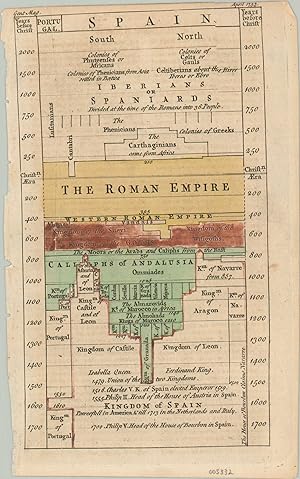
Chart of Universal History - Spain - Revolutionizing data visualization in the mid-18th century.
Publication Date: 1753
Seller: Curtis Wright Maps, Berwyn, IL, U.S.A.
Seller Rating:

Condition: Very Good. "An Account of the Chart of Universal History, from which we have taken the Kingdom of Spain, and distinguished the Periods and extent of Conquests y different colors, the Yellow shewing the Roman Power, the Red that of the Goths; and the Green when and how far the Moors prevailed (See Map annexed)" - Text, accompanying page. This fantastic diagram outlining nearly 4,000 years of Spanish history was originally designed in 1753 by the talented cartographer Thomas Jeffreys. It was but a small part of his much larger Chart of Universal History, which attempted to display for easy comprehension the entirety of known history (from an admittedly Western perspective). The section was published in the April 1753 issue of Gentlemen's magazine. The related article describes Jeffreys' diagram as "the best help to artificial memory that ever was contrived, and the first invention ever hit upon for uniting the idea of time and space." While this is a bit of an overstatement, spacing the chart as a continuous field "directs it to the temporal boundaries of historical entities and events" (Rosenberg/Grafton) and offered a novel visualization of historic data. Source: Rosenberg, and Grafton. Cartographies of Time. New York, Princeton Architectural Press, 2010." Sheet Width (in) 7.5 Sheet Height (in) 4.5 Condition Description Two sheets (chart and text) disbound from a 1753 edition of London's Gentleman's Magazine. Rough edges where formly bound and some light soiling, The timeline features nice original hand color, with the red fading to brown. Good to very good overall.
-
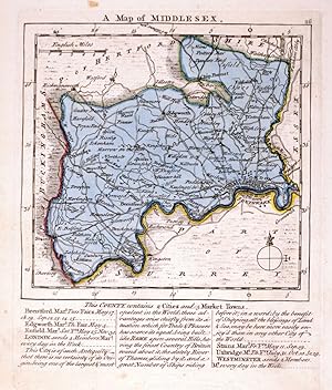
A Map of Middlesex.
Published by London, Robert Sayer, John Bennett, John & Carrington Bowles, 1775. 175 x 145mm (7 x 5ľ inches)., 1775
Original colour; very minor spotting in the margins, otherwise a fine example. A map of the county from, 'The Small English Atlas'.
-
Three Speeches Against Continuing the Army, &c. As They were Spoken In The House of Commons The Last Session of Parliament, To which are Added, The Reasons given by the Lords, who Protested against the Bill for Punishing Mutiny and Desertion.
Published by London: Printed for John Morphew, 1718., 1718
Seller: D & E LAKE LTD. (ABAC/ILAB), Toronto, ON, Canada
Seller Rating:

First Edition
8vo. pp. 46. disbound. First Edition.
-
![Seller image for [Three Tory Statesmen, 1793.] Autograph Signatures of 'Mornington' [Marquis Wellesley, Wellington's brother], 'Bayham' [Marquis Camden, Ireland connection] and 'J. Th. Townshend' [Viscount Sydney of St Leonards], on part of parliamentary document. for sale by Richard M. Ford Ltd](https://pictures.abebooks.com/inventory/md/md31703296002.jpg)
[Three Tory Statesmen, 1793.] Autograph Signatures of 'Mornington' [Marquis Wellesley, Wellington's brother], 'Bayham' [Marquis Camden, Ireland connection] and 'J. Th. Townshend' [Viscount Sydney of St Leonards], on part of parliamentary document.
Published by Dated at foot 'July ', 1793
Seller: Richard M. Ford Ltd, London, United Kingdom
Seller Rating:
Manuscript / Paper Collectible
Richard Colley Wellesley (1760-1842), 1st Marquess Wellesley [as Earl of Mornington]; John Jeffreys Pratt (1759-1840), 1st Marquess Camden [as Viscount Bayham]; John Thomas Townshend (1764-1831), 2nd Viscount Sydney of St Leonards. See their entries in the Oxford DNB. On 5.5 x 15.5 cm strip extracted from a document, and laid down on 8 x 21.5 cm part of gilt-edged leaf from an album. In good condition, lightly aged on aged and creased mount. The signatures are written above one another: 'Mornington / Bayham / J. Th. Townshend'. The only other writing, at the foot of the strip is ' / July 1793'. "Camden served as Lord Lieutenant of Ireland in the revolutionary years 1795 to 1798 and as Secretary of State for War and the Colonies between 1804 and 1805.".
-
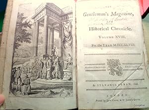
The Gentleman's Magazine for 1748 (12 monthly Parts)
Published by Edward Cave., 1748
Book First Edition
Hardcover. Condition: Good. T.Jeffreys + Thomas Kitchen (illustrator). 1st Edition. 600 pp + 20 page subject index with names of authors of the poetry and articles + monthly title pages. Engraved maps and plates: With 2 folding maps of both Norfolk (UK) and Africa with a map of the Baltic Sea (which has been repaired along fold lines at the bottom area). and a plan of Maestricht. Also 10 copper plates of heraldic interest with coats of arms + Thomas Yeoman ?Weighing Engine? + Plan of the houses burned down or partly destroyed in the Fire in Cornhill the previous month (full page woodcut plate) + 2 cross section views of a Man-o-War and her riggings and compartments + Solar system and astrolabe by Thomas Jeffery?s (as are both the Africa and Baltic Sea maps) a total of 22 engraved plates and maps and also woodcuts in the text (a couple mentioned on plate list never been bound in). Original quarter calf worn and paper boards also, map of the Baltic repaired with archive clear tape along folds. Contents good only with some browning and general wear through handling, text clear, minor edge splits. Sold as described. **Note: A useful work of articles, letters and observations on curiosities and medical/scientific/geographical and geological interests. Octavo. 1748.
-
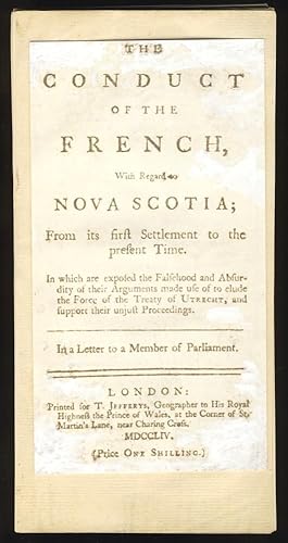
The Conduct of the French With Regards to Nova Scotia; From its first Settlement to the present Time
Published by T. Jefferys, London, 1754
Seller: Schooner Books Ltd.(ABAC/ALAC), Halifax, NS, Canada
Seller Rating:

Unbound with all pages loose. Condition: Facsimile title page. 77,(1) Pp. First page caption reads The Conduct of the French With Respect to the British Dominions in America, particularly Nova Scotia. Errata on page 77. List of Jefferys recent publications on lastpage. Tract written by Jefferys (1719-1771) who was a leading cartographer of his day. This letter written to a member of the british parliament talks about the Acadian boundary dispute.
-
"A View of Amsterdam", ets vervaardigd door Thomas Jeffreys rond 1750, later met de hand gekleurd
Seller: Inter-Antiquariaat Mefferdt & De Jonge, Amsterdam, Netherlands
Seller Rating:
Art / Print / Poster
"A View of Amsterdam", ets vervaardigd door Thomas Jeffreys rond 1750, later met de hand gekleurd. Afm. 17,5 x 39,5 cm. We zien de stad vanaf een fictief punt, ongeveer 20 meter boven de Amstel, richting de Hogesluis. Ten zuiden van de huidige Sarphatistraat-Stadhouderskade was de omgeving van Amsterdam zeer landelijk. Er waren tuinen met soms een klein huisje erin, later bouwden rijke Amsterdammers aan de westelijke Amsteloever tientallen buitenplaatsen. Links van de rivier op de Amsteldijk, herberg de Berebijt. De naam ontleende het etablissement aan de berengevechten die hier in de 17de eeuw werden gehouden. Hiervandaan vertrokken de trekschuiten naar Utrecht; voor de trekschuit naar Muiden en Weesp moest men aan de overkant zijn, bij uitspanningen Lokhorst en De IJsbreker op de Weesperzijde. Onder de voorstelling een uitgebreide legenda met publieke gebrouwen en bastions. Prijs: Euro 495,-.
-
A Chart opf the Gulf of St. Laurence, Composed from a Great Number of Actual Surveys and other Materials, Regulated and Connected by Astronomical Observations.
Published by Sayer & Bennett, London, 1775
Seller: Alexandre Antique Prints, Maps & Books, Toronto, ON, Canada
Seller Rating:
Map
Condition: Very Good. This is the first state of the map (according to Kershaw), published in "The American Atlas."An impressive nautical chart depicting the Gulf of the St. Lawrence. Depth soundings have been noted along most of the coastlines. A small table denotes place names and their associated longitude and latitude sits in the top of the image., Size : 365x512 (mm), 14.37x20.16 (Inches), Hand Colored, 0.
-
![Seller image for A Chart of North and South America, Including the Atlantic and Pacific Oceans, with the Nearest Coasts of Europe, Africa, and Asia. Chart Containing Part of the Icy Sea with the Adjacent Coast of Asia and America. Chart Comprizing Greenland with the Countries and Islands About Baffin's Bay and Part of Hudson's Bay. [Original Hand-Coloured 1775 Map Sheet 1 Only]. for sale by Aquila Books(Cameron Treleaven) ABAC](https://pictures.abebooks.com/inventory/md/md11016424324.jpg)
A Chart of North and South America, Including the Atlantic and Pacific Oceans, with the Nearest Coasts of Europe, Africa, and Asia. Chart Containing Part of the Icy Sea with the Adjacent Coast of Asia and America. Chart Comprizing Greenland with the Countries and Islands About Baffin's Bay and Part of Hudson's Bay. [Original Hand-Coloured 1775 Map Sheet 1 Only].
Published by Fleet Street, London Robert Sayer & J. Bennett 1775, 1775
Seller: Aquila Books(Cameron Treleaven) ABAC, Calgary, AB, Canada
Association Member: ABAC ILAB PBFA
Seller Rating:
Book
Condition: very good. First sheet of a three part 1775 map. 20" X 45" (51 X 115 cm). Original map on thick paper which consists of two parts which have been attached at the center. Several verticle creases from being once folded into an atlas. Slight soiling. A few small closed tears at edges. Top left corner trimmed slightly. Hand colouring along outlines of land masses in yellow and green. Copper engraving hand-coloured with water colour. very good A beautiful map with fine detailing. This is the top portion only of a three part atlas map. Printed beneath title above Baffin's Bay is a comparative table showing comparisons of observations of exact geographic locations with dates and names of observers. Printed beneath "Northern Ocean" is a table of "Latitudes observed by Captn. Behring on the Coast of Siberia." Thomas Jefferys (c.a. 1710-1771) was one of the most significant English cartographers of the eighteenth century. Working as an engraver, geographer and publisher, he created some of the most important English and American maps of his day. He was appointed Geographer to Frederick Prince of Wales in 1748 and later served as Geographer to George III. One of his first maps is a "Plan of London and Westminster" (1732). This map is from "The American Atlas".
-
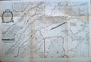
An Exact Chart of the River St. Laurence from Fort Frontenac to the Island of Anticosti Shewing the Soundings, Rocks, Shoals & c. with View of the Lands and All Necessary Instructions for Navigating That River to Quebec
Published by London, London, 1775
Seller: High Ridge Books, Inc. - ABAA, South Deerfield, MA, U.S.A.
Association Member: ABAA ESA ILAB SNEAB
Seller Rating:
Removed from Jeffreys' American Atlas, this is an excellent copy with no discoloration or tears. One small hole at a fold junction. Original outline color. This is the definitive 18th century map of the St. Lawrence river, with extensive navigational notes printed on the map. Insets plans of the Roads of Tadousac, The Seven Islands, St. Nicholas or English Harbor, and The Traverse of Passage from Cape Torment into the South Channel of Orleans Island. The map is arranged such that the course of the river from its beginning at Lake Ontario to Quebec City is at the upper left with the central portion of the sheet being the course from Quebec to the mouth of the river at Nova Scotia and Labrador. Fourth state, Stevens & Tree 76(d).
-
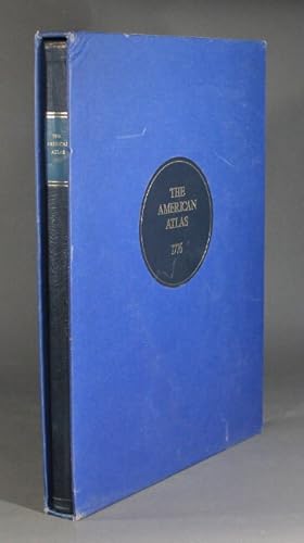
The American atlas 1776
Published by Times Newspapers Limited in association with the Royal Geographic Society and David Paradine Developments Limited, London, 1976
Seller: Rulon-Miller Books (ABAA / ILAB), St. Paul, MN, U.S.A.
Association Member: ABAA ILAB RMABA
Seller Rating:
Limited to 200 copies (this, no. 16), large folio, pp. [8] plus 30 hand-colored maps, all but 1 either folding or double-page; original half blue morocco over blue marbled paper-covered boards, blue morocco label lettered in gilt on upper cover; publisher's slipcase; very light wear else near fine throughout. Originally published in London, and printed and sold by R. Sayer and J. Bennett, 1776.
-
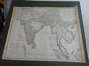
LARGE MAP OF THE EAST INDIES
Published by ROBERT SAYER, 1772
Seller: Gordon Leete, MARKET HARBOROUGH, LEICS, United Kingdom
Association Member: PBFA
Seller Rating:
Map
No Binding. Condition: Very Good. C1772 LARGE MAP OF THE EAST INDIES 700MM X 570MM VGC NO RETORATION CLEAN WIDE MARGINS HAND COLOURED AN IMPRESSIVE EARLY MAP OF EAST ASIA.
-
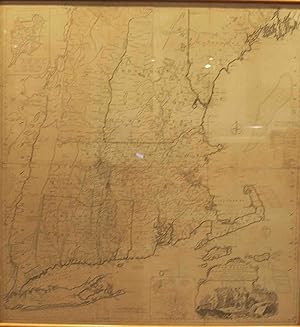
Map of the Most Inhabited Part of New England, Containing .
Published by London, London, 1774
Seller: High Ridge Books, Inc. - ABAA, South Deerfield, MA, U.S.A.
Association Member: ABAA ESA ILAB SNEAB
Seller Rating:
Framed, backing not determined. 4 sheets joined, top margin of bottom sheets trimmed. Light wear in western Massachusetts near bottom of the top left sheet. Dated November 29, 1774. A good copy of one of the great 18th century maps of New England. Full color in Vermont, outline color throughout. Uniform age-toning throughout. Stevens & Tree 33(d).