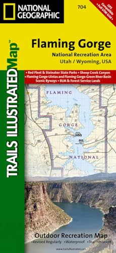
Flaming Gorge National Recreation Area Map (National Geographic Trails Illustrated Map, 704)

� Waterproof � Tear-Resistant � Topographic Map
The red cliffs of the Green River's Flaming Gorge stretch from Wyoming's high deserts to the wooded slopes of Utah's Uinta Mountains. Expertly researched and created in partnership with local land management agencies, National Geographic's Trails Illustrated map of Flaming Gorge National Recreation Area provides an unparalleled tool for exploring this magnificent region. Some of the key areas of interest featured on this map include Lucerne Valley; Firehole Canyon; Sheep Creek Canyon Geological Area; Red Fleet and Steinaker state parks; and a portion of the Little Hole National Recreation Trail.
Designed with a wide range of visitors in mind, this map features detailed topography with contour lines, shaded relief and elevations; easy-to-read trails that are marked according to use; clearly defined, color-coded boundaries of state parks, wildlife areas, conservation areas, Indian reservations, and private land; and an accurate road network. If you're taking in the scenery by car, several scenic byways and backways are labeled including Flaming Gorge?Uintas, Flaming Gorge?Green River Basin, Sheep Creek Spirit Lake Loop, Sheep Creek Geologic Loop, and Browns Park. Some of the many recreation features noted include campgrounds, trailheads, interpretive trails, river access, boat launches, marinas, fishing access, and cross country ski areas.
Every Trails Illustrated map is printed on "Backcountry Tough" waterproof, tear-resistant paper. A full UTM grid is printed on the map to aid with GPS navigation.
Other features found on this map include: Ashley National Forest, Black Mountain, Blacks Fork, Flaming Gorge Dam, Flattop Mountain, Marsh Peak, Uinta Mountains.
- Map Scale = 1:75,000
- Sheet Size = 25.5" x 37.75"
- Folded Size = 4.25" x 9.25"
"synopsis" may belong to another edition of this title.
About the Author:
Founded in 1915 as the Cartographic Group, the first division of National Geographic, National Geographic Maps has been responsible for illustrating the world around us through the art and science of mapmaking.Today, National Geographic Maps continues this mission by creating the world's best wall maps, recreation maps, atlases, and globes which inspire people to care about and explore their world.
"About this title" may belong to another edition of this title.
- PublisherNatl Geographic Society Maps
- Publication date2023
- ISBN 10 1566954142
- ISBN 13 9781566954143
- BindingMap
- Number of pages2
Buy New
Learn more about this copy
US$ 19.43
Shipping:
FREE
Within U.S.A.
Top Search Results from the AbeBooks Marketplace
Stock Image
Flaming Gorge National Recreation Area (National Geographic Trails Illustrated Map, 704)
Published by
Natl Geographic Society Maps
(2020)
ISBN 10: 1566954142
ISBN 13: 9781566954143
New
Quantity: 1
Seller:
Rating
Book Description Map. Condition: New. Seller Inventory # DADAX1566954142
Buy New
US$ 19.43
Convert currency
Stock Image
Flaming GorgeEast Uintas Trails Illustrated Other Rec Areas National Geographic Trails Illustrated Map
Published by
National Geographic Maps
(2012)
ISBN 10: 1566954142
ISBN 13: 9781566954143
New
Quantity: 11
Seller:
Rating
Book Description UNK. Condition: New. New Book. Shipped from UK. Established seller since 2000. Seller Inventory # EA-9781566954143
Buy New
US$ 23.90
Convert currency
Stock Image
Flaming Gorge/east Uintas
Published by
National Geographic Maps Division 2012-08-02, Washington, D.C.
(2012)
ISBN 10: 1566954142
ISBN 13: 9781566954143
New
Quantity: 5
Seller:
Rating
Book Description sheet map (folded). Condition: New. Language: ENG. Seller Inventory # 9781566954143
Buy New
US$ 19.23
Convert currency
Stock Image
Flaming Gorge/east Uintas: Trails Illustrated Other Rec. Areas
Seller:
Rating
Book Description Sheet map, folded. Condition: New. New copy - Usually dispatched within 4 working days. Seller Inventory # B9781566954143
Buy New
US$ 17.42
Convert currency
Stock Image
Flaming Gorge National Recreation Area (National Geographic Trails Illustrated Map, 704)
Published by
Natl Geographic Society Maps
(2020)
ISBN 10: 1566954142
ISBN 13: 9781566954143
New
Quantity: 2
Seller:
Rating
Book Description Map. Condition: New. Brand New!. Seller Inventory # VIB1566954142
Buy New
US$ 43.70
Convert currency
Stock Image
Flaming Gorge National Recreation Area/East Uintas Trails Illustrated Map # 704
Published by
Natl Geographic Society Maps
(2009)
ISBN 10: 1566954142
ISBN 13: 9781566954143
New
Quantity: 1
Seller:
Rating
Book Description Map. Condition: Brand New. map edition. 2 pages. 0.25x9.25x4.25 inches. In Stock. Seller Inventory # 1566954142
Buy New
US$ 32.69
Convert currency
Stock Image
Flaming GorgeEast Uintas Trails Illustrated Other Rec Areas National Geographic Trails Illustrated Map
Published by
National Geographic Maps
(2012)
ISBN 10: 1566954142
ISBN 13: 9781566954143
New
Quantity: 11
Seller:
Rating
Book Description UNK. Condition: New. New Book. Shipped from UK. Established seller since 2000. Seller Inventory # EA-9781566954143
Buy New
US$ 19.17
Convert currency
Stock Image
Flaming Gorge/east Uintas (Folded)
Published by
National Geographic Maps, Evergreen
(2012)
ISBN 10: 1566954142
ISBN 13: 9781566954143
New
Quantity: 1
Seller:
Rating
Book Description Folded. Condition: new. Folded. National Geographic's Trails Illustrated Maps are the most detailed and up-to-date topographic recreation maps available for US National Parks, National Forests and other popular outdoor recreation areas. A necessity for exploring the outdoors, each map is printed on waterproof, tear-resistant material. They also contain key safety and contact information, GPS and compass coordinates, Leave No Trace ethical guidelines and hundreds of points-of-interest, including scenic viewpoints, campgrounds, boat launches, swimming areas, marine sanctuaries and wildlife refuges. Coverage includes Ashley National Forest; Flaming Gorge National Recreation Area; Eastern Uinta Mountains; Steinaker State Recreation Area; Green River, Wyoming; McKinnon Junction, Dutch John, Dry Fork, Manila and Greendale; Matt Warner, Cedar View and Beaver Meadow reservoirs; and the Red Canyon of the Green River. Includes UTM tick marks for use with your GPS unit. Shipping may be from our Sydney, NSW warehouse or from our UK or US warehouse, depending on stock availability. Seller Inventory # 9781566954143
Buy New
US$ 30.13
Convert currency
Stock Image
Flaming Gorge/east Uintas (Folded)
Published by
National Geographic Maps, Evergreen
(2012)
ISBN 10: 1566954142
ISBN 13: 9781566954143
New
Quantity: 1
Seller:
Rating
Book Description Folded. Condition: new. Folded. National Geographic's Trails Illustrated Maps are the most detailed and up-to-date topographic recreation maps available for US National Parks, National Forests and other popular outdoor recreation areas. A necessity for exploring the outdoors, each map is printed on waterproof, tear-resistant material. They also contain key safety and contact information, GPS and compass coordinates, Leave No Trace ethical guidelines and hundreds of points-of-interest, including scenic viewpoints, campgrounds, boat launches, swimming areas, marine sanctuaries and wildlife refuges. Coverage includes Ashley National Forest; Flaming Gorge National Recreation Area; Eastern Uinta Mountains; Steinaker State Recreation Area; Green River, Wyoming; McKinnon Junction, Dutch John, Dry Fork, Manila and Greendale; Matt Warner, Cedar View and Beaver Meadow reservoirs; and the Red Canyon of the Green River. Includes UTM tick marks for use with your GPS unit. Shipping may be from our UK warehouse or from our Australian or US warehouses, depending on stock availability. Seller Inventory # 9781566954143
Buy New
US$ 25.00
Convert currency