Virgin Islands National Park Map (National Geographic Trails Illustrated Map, 236)

� Waterproof � Tear-Resistant � Topographic Map
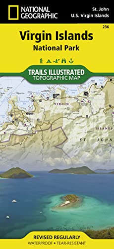
Virgin Islands National Park is an island paradise of white sand beaches and turquoise water. Created in cooperation with the National Park Service and others, National Geographic's Trails Illustrated map of Virgin Islands National Park is a complete travel guide to to this tropical wonderland. Ferry routes will get you to the main visitor center at Cruz Bay. Use the trail guide, with trail descriptions, lengths and hiking times, to select a suitable route. Follow the trail on the topographic map that is complete with contour lines and elevations, as well as key points of interest and nearby facilities, including parking, campgrounds. showers, picnic areas, restrooms and beaches.
Descriptions of the snorkeling areas along with a snorkeling and diving ethics guide is provided. Areas of coral reefs are marked on the map as are the boundaries of Virgin Islands Coral Reef National Monument. For those who prefer navigating their own boat, anchoring information, safety tips and regulations are included. The color-coded buoys surrounding the island are displayed on the map as are scuba moorings. Information about birdwatching and park vegetation along with illustrations of a number of bird species and local flora is provided as well. The map also covers nearby Great Thatch Island, Little Thatch Island, Frenchmans Cay, Tortola Island, Dog Island, Lovango Cay and Durloe Cays.
Every Trails Illustrated map is printed on "Backcountry Tough" waterproof, tear-resistant paper. A full UTM grid is printed on the map to aid with GPS navigation.
Other features found on this map include: Saint John, Virgin Islands Coral Reef National Monument, Virgin Islands National Park.
- Map Scale = 1:22,000
- Sheet Size = 37.75" x 25.5"
- Folded Size = 4.25" x 9.25"
"synopsis" may belong to another edition of this title.
About the Author:
Founded in 1915 as the Cartographic Group, the first division of National Geographic, National Geographic Maps has been responsible for illustrating the world around us through the art and science of mapmaking.Today, National Geographic Maps continues this mission by creating the world's best wall maps, recreation maps, atlases, and globes which inspire people to care about and explore their world.
"About this title" may belong to another edition of this title.
- PublisherNational Geographic Maps
- Publication date2020
- ISBN 10 1566953464
- ISBN 13 9781566953467
- BindingMap
- Number of pages2
- Rating
Buy New
Learn more about this copy
US$ 10.24
Shipping:
US$ 3.99
Within U.S.A.
Top Search Results from the AbeBooks Marketplace
Stock Image
Virgin Islands National Park (National Geographic Trails Illustrated Map, 236)
Published by
National Geographic Maps
(2020)
ISBN 10: 1566953464
ISBN 13: 9781566953467
New
Quantity: 2
Seller:
Rating
Book Description Condition: New. Brand New! Not Overstocks or Low Quality Book Club Editions! Direct From the Publisher! We're not a giant, faceless warehouse organization! We're a small town bookstore that loves books and loves it's customers! Buy from Lakeside Books!. Seller Inventory # OTF-9781566953467
Buy New
US$ 10.24
Convert currency
Stock Image
Virgin Islands National Park Map (National Geographic Trails Illustrated Map, 236)
Published by
National Geographic Maps
(2020)
ISBN 10: 1566953464
ISBN 13: 9781566953467
New
Quantity: 5
Seller:
Rating
Book Description Condition: New. Seller Inventory # I-9781566953467
Buy New
US$ 17.00
Convert currency
Stock Image
Virgin Islands National Park Map (National Geographic Trails Illustrated Map, 236)
Published by
National Geographic Maps
(2020)
ISBN 10: 1566953464
ISBN 13: 9781566953467
New
Quantity: 1
Seller:
Rating
Book Description Condition: New. Book is in NEW condition. Seller Inventory # 1566953464-2-1
Buy New
US$ 19.41
Convert currency
Stock Image
Virgin Islands National Park Map (National Geographic Trails Illustrated Map, 236)
Published by
National Geographic Maps
(2020)
ISBN 10: 1566953464
ISBN 13: 9781566953467
New
Quantity: 1
Seller:
Rating
Book Description Condition: New. New! This book is in the same immaculate condition as when it was published. Seller Inventory # 353-1566953464-new
Buy New
US$ 19.42
Convert currency
Stock Image
Virgin Islands National Park, U.S.V.I. - Trails Illustrated Map # 236
Published by
Natl Geographic Society Maps
(2006)
ISBN 10: 1566953464
ISBN 13: 9781566953467
New
Quantity: 1
Seller:
Rating
Book Description Map. Condition: New. 3. Seller Inventory # DADAX1566953464
Buy New
US$ 19.43
Convert currency
Stock Image
Virgin Islands National Park
Published by
National Geographic Maps Division 2012-08-02, Washington, D.C.
(2012)
ISBN 10: 1566953464
ISBN 13: 9781566953467
New
Quantity: 5
Seller:
Rating
Book Description sheet map (folded). Condition: New. Language: ENG. Seller Inventory # 9781566953467
Buy New
US$ 16.66
Convert currency
Stock Image
Virgin Islands National Park Trails Illustrated National Parks National Geographic Trails Illustrated Map
Published by
National Geographic Maps Division
(2012)
ISBN 10: 1566953464
ISBN 13: 9781566953467
New
Quantity: 5
Seller:
Rating
Book Description UNK. Condition: New. New Book. Shipped from UK. Established seller since 2000. Seller Inventory # EA-9781566953467
Buy New
US$ 23.90
Convert currency
Stock Image
National Geographic Trails Illustrated Map Virgin Islands National Park: Virgin Islands
Published by
Natl Geographic Society Maps
(2011)
ISBN 10: 1566953464
ISBN 13: 9781566953467
New
Quantity: 2
Seller:
Rating
Book Description Sheet map. Condition: Brand New. map edition. 2 pages. 0.25x9.25x4.25 inches. In Stock. Seller Inventory # x-1566953464
Buy New
US$ 15.51
Convert currency
Stock Image
Virgin Islands National Park Map (National Geographic Trails Illustrated Map, 236)
Published by
National Geographic Maps
(2020)
ISBN 10: 1566953464
ISBN 13: 9781566953467
New
Paperback
Quantity: 1
Seller:
Rating
Book Description Paperback. Condition: new. New Copy. Customer Service Guaranteed. Seller Inventory # think1566953464
Buy New
US$ 27.81
Convert currency
Seller Image
Virgin Islands National Park Map
Published by
NATL GEOGRAPHIC MAPS Jan 2020
(2020)
ISBN 10: 1566953464
ISBN 13: 9781566953467
New
Quantity: 1
Seller:
Rating
Book Description Karte. Condition: Neu. Neuware -Trails Illustrated topographic maps are the most detailed and up-to-date recreation maps available for these national parks, national forests and popular outdoor recreation areas. This map includes: the island of St. John; the entire Virgin Islands National Park; Virgin Islands Coral Reef National Monument; Mount Sage National Park; Tortola Island; Great Thatch Island; Little Thatch Island; Frenchmans Cay; Lovango Cay; Congo Cay; Mingo Cay; Dog Island; Hawksnest Bay; Durloe Cays; Durloe Channel; Cinnamon Bay; Trunk Bay; Mary Point; Francis Bay; and UTM grids for GPS. 2 pp. Englisch. Seller Inventory # 9781566953467
Buy New
US$ 17.59
Convert currency