Order Total (1 Item Items):
Shipping Destination:

Atlas United States Containing by Tanner Henry (9 results)
Skip to main search results
Product Type
- All Product Types
- Books (8)
- Magazines & Periodicals
- Comics
- Sheet Music
- Art, Prints & Posters
- Photographs
- Maps (1)
-
Manuscripts &
Paper Collectibles
Condition
Binding
Collectible Attributes
Free Shipping
Seller Location
Seller Rating
-

Atlas of the United States: Containing Separate Maps of Each State and Territory of the North American Union. (Paperback or Softback)
Published by Gale, Sabin Americana 2/22/2012, 2012
ISBN 10: 1275813453ISBN 13: 9781275813458
Book
Paperback or Softback. Condition: New. Atlas of the United States: Containing Separate Maps of Each State and Territory of the North American Union. 0.38. Book.
-
Atlas of the United States: Containing Separate Maps of Each State and Territory of the North American Union.
Published by Gale, Sabin Americana, 2012
ISBN 10: 1275813453ISBN 13: 9781275813458
Book
Condition: New.
-
Atlas of the United States containing separate maps of each state and territory of the North American Union
Published by Gale, Sabin Americana, 2012
ISBN 10: 1275813453ISBN 13: 9781275813458
Book Print on Demand
PAP. Condition: New. New Book. Shipped from UK. THIS BOOK IS PRINTED ON DEMAND. Established seller since 2000.
-
Atlas of the United States containing separate maps of each state and territory of the North American Union
Published by Gale, Sabin Americana, 2012
ISBN 10: 1275813453ISBN 13: 9781275813458
Book Print on Demand
PAP. Condition: New. New Book. Delivered from our UK warehouse in 4 to 14 business days. THIS BOOK IS PRINTED ON DEMAND. Established seller since 2000.
-

Atlas of the United States: Containing Separate Maps of Each State and Territory of the North American Union.
Published by GALE SABIN AMERICANA, 2012
ISBN 10: 1275813453ISBN 13: 9781275813458
Book
Condition: New.
-

A New Universal Atlas Containing Maps of the various Empires, Kingdoms, States and Republics of the World. With a special map of each of the United States. Plans of cities Comprehended in seventy sheets and forming a series of One Hundred and Seventeen maps, plans and sections.
Published by S. Augustus Mitchell, 1846
Book
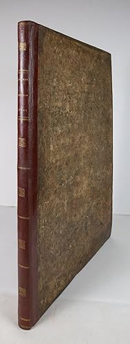
Hardcover. Condition: Good. Philadelphia: S. Augustus Mitchell, 1846. Folio (17 3/8" x 14", 440mm x 350mm). With 71 (of 72; lacking map 71: Palestine) engraved hand-colored maps. Bound in the publisher's half red morocco over marbled boards. On the front board, author and title gilt to a red sheep label. On the spine, six transverse gilt fillets, making six panels. Extremities worn, with loss at the head and tail. Front board starting. Tanned throughout, with some foxing. Some chips to the lower edge of the front free end-paper. A little offsetting and some pigment burn to the maps. Henry Schenck Tanner (1786-1858) was the pre-eminent American cartographer, engraver and publisher of his day, considered the Golden Age of American publishing. Born in New York City, Tanner was active in Philadelphia, and pioneered the field of cartographic epidemiology; his 1832 account of the 1817 cholera epidemic combined up-to-date maps with public health data to comprehend the spread of the disease. His accurate and detailed Universal Atlas (first published in 1836) went through several publishers, culminating in the present item, the first published by Samuel Augustus Mitchell.
-
A New Universal Atlas Containing Maps of the various Empires, KIngdoms, States and Republics of the World With a special map of each of the United States, plans of Cities &c. Comprehended in seventy sheets and forming a series of One Hundred and Seventeen Maps, Plans and Sections.
Publication Date: 1836
Map First Edition
Philadelphia, 1836, First Atlas Edition. Folio (400 x 330mm), original half morocco gilt; pp. (vi) + (6)(publisher's ads); engr. title with vignette, 68 numbered maps & town plans and one plate, all but title with bright original hand colour. Complete as index (70 plates including title). Ink mss. initials on prelims. A fine example of an early American atlas, which includes maps of 27 American states and territories on 24 plates and town plans of New York, Philadelphia and Washington. The plate compares river lengths and mountain heights. The title vignette depicts the arrival of Columbus in the New World. Tanner produced this smaller and more affordable format atlas to reach a wider market, issuing the maps in parts from 1834 although many of the maps have 1833 dates. This atlas appears to be an early first edition, compiled from the parts: the traces of blue paper on the back of the New York plan are likely to be from a wrapper. A second edition of 1838 still used the 1836 engraved title, but the dates of the maps were changed to 1836 (for example the world map). Later editions were published by Carey & Hart (from 1842) and Samuel Augustus Mitchell (from 1846).
-
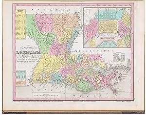
Atlas of the United States, Containing Separate maps of Each State and Territory of the North American Union.
Published by Philadelphia: by the author, 1835., 1835
First Edition
4to., (15 4/8 x 12 4/8 inches). 4-page publisher's advertisement at end. Full-page engraved map of the United States (not called for in the Index), and 24 state maps all with original hand colour in full. Contemporary half black morocco, marbled paper boards, red morocco lettering-piece on the front cover, the smooth spine ruled in six compartments each decorated with a small gilt tool of the Pease family crest (extremities lightly scuffed). Provenance: With the engraved armorial bookplate of William M. Maude on the front paste-down; anonymous sale Christie's 27th October 1982, lot 157; purchased by Charles W. Traylen for Christopher Henry Beaumont Pease, Lord Wardington (1924-2005), his sale 10th October 2006, lot 495 First edition. "Tanner was a leading figure in establishing commercial map publishing in America and brought the atlas as a cartographic form to early maturity during the "golden age" of American copperplate printing. He combined the skills of a geographer with those of an editor and engraver to create authoritative maps during a period of unprecedented growth in topographical knowledge of North America. He represented the emergence in the world of American publishers of specialized maps, and he placed map compilation and atlas design on a newly scientific basis, introducing uniform map scales for maps in atlases and documentation of sources employed. He crucially reinforced the brief impetus Melish had given to the rise of homegrown American map publishing and set standards that later publishers took for granted" (Michael P. Conzen for ADNB). From the distinguished library of Lord Wardington whose collection of Atlases was unique: "a panoply of the history of cartography and of great mapmakers" (Andrew Phillips "An Appreciation", Sotheby's sale catalogue). Phillips, Atlases 1380 (not listing general map). Catalogued by Kate Hunter.
-
A New American Atlas containing maps of the Several States of the North American Union. Projected and drawn on a Uniform Scale from Documents found in the public Offices of the United States and State Governments, and other Original and Authentic Information
Published by H.S. Tanner, Philadelphia, 1823
First Edition Signed
Hardcover. Condition: Near fine. First. WITH CONGRESSIONAL PROVENANCE. Philadelphia: H.S. Tanner, 1823. First edition. Broadsheet (23 �" x 16 5/8", 603mm x 423mm). [Full description available.] With an engraved title-page, 16 double-sheet hand-colored engraved maps and 3 folding hand-colored engraved maps (one three sheets, one eight sheets). Bound in contemporary half red sheep over marbled boards. On the spine, eight transverse double gilt fillets. In the panels, gilt fleurons. Author and title gilt in the second panel. Conserved in February 2021 by James and Stuart Brockman (full report available). Some foxing, offsetting and tanning to the text and maps. Signed by John H. Bryan on the title-page and on the index (Jn. H. Bryan). Altogether an exceptionally sound copy in its original trappings. Henry Schenk Tanner (1786-1858) was a New-York-born cartographer who pioneered the field of cartographic epidemiology; his 1832 account of the 1817 cholera epidemic combined up-to-date maps with public health data to comprehend the spread of the disease. Tanner's survey of the U.S. (the magnificent eight-sheet map shows the country in its North American context, and would go on to be republished many times throughout the XIXc) is distinguished by its exceptionally accurate and detailed plates of the states. Collated as it was from authorities held in statehouses, the atlas was slow in production and expensive; it was issued in parts from 1819 to 1823. The present copy is the first edition in book form, distinguished by its 18 pages of preliminaries (fewer in the 3- and 5-part issues). John Herritage (or Heritage) Bryan (1798-1870) was a Representative from North Carolina from 1825 to 1829. While in the House, he served on the Committee on Roads and Canals. Bryan was a trustee of the University of North Carolina, Chapel Hill for more than four decades (1823-1868). Howes T 29; Phillips 3669; Sabin 94319; Wheat, Transmississippi II p. 82 and n.1.