
Order Total (1 Item Items):
Shipping Destination:

national geographic maps jan 2020 (12 results)
Skip to main search results
Product Type
- All Product Types
- Books (6)
- Magazines & Periodicals
- Comics
- Sheet Music
- Art, Prints & Posters
- Photographs
- Maps (6)
-
Manuscripts &
Paper Collectibles
Condition
- All Conditions
- New
- Used
Binding
- All Bindings
- Hardcover
- Softcover
Collectible Attributes
- First Edition
- Signed
- Dust Jacket
- Seller-Supplied Images (11)
- Not Printed On Demand
Seller Location
Seller Rating
-
![Seller image for French Broad and Nolichucky Rivers Map [Cherokee and Pisgah National Forests] for sale by BuchWeltWeit Ludwig Meier e.K.](https://pictures.abebooks.com/inventory/md/md31700469687.jpg)
French Broad and Nolichucky Rivers Map [Cherokee and Pisgah National Forests]
Published by NATL GEOGRAPHIC MAPS Jan 2020, 2020
ISBN 10: 1566953871ISBN 13: 9781566953870
Book
Karte. Condition: Neu. Neuware -Coverage includes Cherokee National Forest/Northern Districts; Greenville and Newport; and Sampson Mountain Wilderness Area. Boating Access Points: Nolichucky and French Broad Rivers. Scenic Drives: Foothills Parkway. Includes coverage of the Appalachian Trail. Includes UTM grids for use with your GPS unit and a trail mileage matrix. 2 pp. Englisch.
-

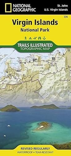
Virgin Islands National Park Map
Published by NATL GEOGRAPHIC MAPS Jan 2020, 2020
ISBN 10: 1566953464ISBN 13: 9781566953467
Book
Karte. Condition: Neu. Neuware -Trails Illustrated topographic maps are the most detailed and up-to-date recreation maps available for these national parks, national forests and popular outdoor recreation areas. This map includes: the island of St. John; the entire Virgin Islands National Park; Virgin Islands Coral Reef National Monument; Mount Sage National Park; Tortola Island; Great Thatch Island; Little Thatch Island; Frenchmans Cay; Lovango Cay; Congo Cay; Mingo Cay; Dog Island; Hawksnest Bay; Durloe Cays; Durloe Channel; Cinnamon Bay; Trunk Bay; Mary Point; Francis Bay; and UTM grids for GPS. 2 pp. Englisch.
-
![Stock image for Linville Gorge, Mount Mitchell Map [Pisgah National Forest] for sale by BuchWeltWeit Ludwig Meier e.K.](https://pictures.abebooks.com/isbn/9781566954228-us-300.jpg)
Linville Gorge, Mount Mitchell Map [Pisgah National Forest]
Published by NATL GEOGRAPHIC MAPS Jan 2020, 2020
ISBN 10: 1566954223ISBN 13: 9781566954228
Book
Karte. Condition: Neu. Neuware -Coverage includes Pisgah National Forest, Grandfather Ranger District (complete) and Appalachian Ranger District. Towns: Black Mountain, Marion, Morganton, Linville, Burnsville. Wilderness areas: Linville Gorge. Scenic drives: Blue Ridge Parkway. Other highlights: Mount Mitchell State Park, Grandfther Mountain Biosphere Reserve, Wilson Creek Wild and Scenic River, Brown Mountain OHV Area, South Toe River, Mountains-to-Sea Trail, and Lake James State Park. Includes UTM grids for use with your GPS unit and a trail mileage matrix. 2 pp. Englisch.
-

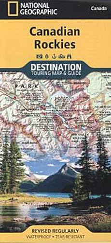
Canadian Rockies Map
Published by NATL GEOGRAPHIC MAPS Jan 2020, 2020
ISBN 10: 1597755133ISBN 13: 9781597755139
Book
Karte. Condition: Neu. Neuware -National Geographic's Canadian Rockies Destination Map strikes the perfect balance between map and guidebook and is an ideal resource for touring this culturally and geographically unique region. Canada's share of the Rocky Mountains averages approximately 100 miles across (160 kilometers) and runs from Waterton Lakes National Park on the Alberta-Montana border northwest toward the Yukon territory. DestinationMaps are condensed guide books that are an ideal resource for touring such culturally and geographically unique regions. Printed on waterproof and tear-resistant material. 2 pp. Englisch.
-
![Seller image for French Broad and Nolichucky Rivers Map [Cherokee and Pisgah National Forests] for sale by Wegmann1855](https://pictures.abebooks.com/inventory/md/md31536878923.jpg)
French Broad and Nolichucky Rivers Map [Cherokee and Pisgah National Forests]
Published by NATL GEOGRAPHIC MAPS Jan 2020, 2020
ISBN 10: 1566953871ISBN 13: 9781566953870
Book
Karte. Condition: Neu. Neuware -Coverage includes Cherokee National Forest/Northern Districts; Greenville and Newport; and Sampson Mountain Wilderness Area. Boating Access Points: Nolichucky and French Broad Rivers. Scenic Drives: Foothills Parkway. Includes coverage of the Appalachian Trail. Includes UTM grids for use with your GPS unit and a trail mileage matrix. 2 pp. Englisch.
-
![Seller image for Linville Gorge, Mount Mitchell Map [Pisgah National Forest] for sale by Wegmann1855](https://pictures.abebooks.com/inventory/md/md31762803976.jpg)
Linville Gorge, Mount Mitchell Map [Pisgah National Forest]
Published by NATL GEOGRAPHIC MAPS Jan 2020, 2020
ISBN 10: 1566954223ISBN 13: 9781566954228
Map
Karte. Condition: Neu. Neuware -Coverage includes Pisgah National Forest, Grandfather Ranger District (complete) and Appalachian Ranger District. Towns: Black Mountain, Marion, Morganton, Linville, Burnsville. Wilderness areas: Linville Gorge. Scenic drives: Blue Ridge Parkway. Other highlights: Mount Mitchell State Park, Grandfther Mountain Biosphere Reserve, Wilson Creek Wild and Scenic River, Brown Mountain OHV Area, South Toe River, Mountains-to-Sea Trail, and Lake James State Park. Includes UTM grids for use with your GPS unit and a trail mileage matrix.
-
Virgin Islands National Park Map
Published by NATL GEOGRAPHIC MAPS Jan 2020, 2020
ISBN 10: 1566953464ISBN 13: 9781566953467
Map
Karte. Condition: Neu. Neuware - Trails Illustrated topographic maps are the most detailed and up-to-date recreation maps available for these national parks, national forests and popular outdoor recreation areas. This map includes: the island of St. John; the entire Virgin Islands National Park; Virgin Islands Coral Reef National Monument; Mount Sage National Park; Tortola Island; Great Thatch Island; Little Thatch Island; Frenchmans Cay; Lovango Cay; Congo Cay; Mingo Cay; Dog Island; Hawksnest Bay; Durloe Cays; Durloe Channel; Cinnamon Bay; Trunk Bay; Mary Point; Francis Bay; and UTM grids for GPS.
-
![Seller image for French Broad and Nolichucky Rivers Map [Cherokee and Pisgah National Forests] for sale by AHA-BUCH GmbH](https://pictures.abebooks.com/inventory/md/md31483008430.jpg)
French Broad and Nolichucky Rivers Map [Cherokee and Pisgah National Forests]
Published by National Geographic Maps Jan 2020, 2020
ISBN 10: 1566953871ISBN 13: 9781566953870
Map
Karte. Condition: Neu. Neuware - Coverage includes Cherokee National Forest/Northern Districts; Greenville and Newport; and Sampson Mountain Wilderness Area. Boating Access Points: Nolichucky and French Broad Rivers. Scenic Drives: Foothills Parkway. Includes coverage of the Appalachian Trail. Includes UTM grids for use with your GPS unit and a trail mileage matrix.
-

Canadian Rockies Map
Published by NATL GEOGRAPHIC MAPS Jan 2020, 2020
ISBN 10: 1597755133ISBN 13: 9781597755139
Map
Karte. Condition: Neu. Neuware - National Geographic's Canadian Rockies Destination Map strikes the perfect balance between map and guidebook and is an ideal resource for touring this culturally and geographically unique region. Canada's share of the Rocky Mountains averages approximately 100 miles across (160 kilometers) and runs from Waterton Lakes National Park on the Alberta-Montana border northwest toward the Yukon territory. DestinationMaps are condensed guide books that are an ideal resource for touring such culturally and geographically unique regions. Printed on waterproof and tear-resistant material.
-
![Seller image for Linville Gorge, Mount Mitchell Map [Pisgah National Forest] for sale by AHA-BUCH GmbH](https://pictures.abebooks.com/inventory/md/md31483042207.jpg)
Linville Gorge, Mount Mitchell Map [Pisgah National Forest]
Published by NATL GEOGRAPHIC MAPS Jan 2020, 2020
ISBN 10: 1566954223ISBN 13: 9781566954228
Map
Karte. Condition: Neu. Neuware - Coverage includes Pisgah National Forest, Grandfather Ranger District (complete) and Appalachian Ranger District. Towns: Black Mountain, Marion, Morganton, Linville, Burnsville. Wilderness areas: Linville Gorge. Scenic drives: Blue Ridge Parkway. Other highlights: Mount Mitchell State Park, Grandfther Mountain Biosphere Reserve, Wilson Creek Wild and Scenic River, Brown Mountain OHV Area, South Toe River, Mountains-to-Sea Trail, and Lake James State Park. Includes UTM grids for use with your GPS unit and a trail mileage matrix.
-
![Seller image for White Mountain National Forest [Map Pack Bundle] for sale by AHA-BUCH GmbH](https://pictures.abebooks.com/inventory/md/md31764399790.jpg)
White Mountain National Forest [Map Pack Bundle]
Published by National Geographic Maps Jan 2020, 2020
ISBN 10: 159775224XISBN 13: 9781597752244
Map
Karte. Condition: Neu. Neuware - - Waterproof - Tear-Resistant - Topographic Maps.