
Order Total (1 Item Items):
Shipping Destination:

9780850543070 - Manchester London Road 1849: Manchester Sheet 34 Old Ordnance Survey Maps of Manchester by Makepeace, Chris (16 results)
Skip to main search results
Product Type
- All Product Types
- Books (14)
- Magazines & Periodicals
- Comics
- Sheet Music
- Art, Prints & Posters
- Photographs
- Maps (2)
- Manuscripts & Paper Collectibles
Condition
Binding
Collectible Attributes
- First Edition
- Signed
- Dust Jacket
- Seller-Supplied Images (2)
- Not Print on Demand (16)
Free Shipping
Seller Location
Seller Rating
-
Condition: As New. Unread book in perfect condition.
-
Manchester (London Road) 1849
Published by Alan Godfrey Maps 1990-04-01, 1990
ISBN 10: 085054307XISBN 13: 9780850543070
Book
hardback. Condition: New. Language: ENG.
-
Condition: New.
-
Manchester London Road 1849 Manchester Sheet 34 Old Ordnance Survey Maps of Manchester
Published by Alan Godfrey Maps, 1990
ISBN 10: 085054307XISBN 13: 9780850543070
Book
UNK. Condition: New. New Book. Shipped from UK. Established seller since 2000.
-
Map. Condition: Brand New. facsimile of 1849 ed edition. 8.19x4.72x0.16 inches. In Stock.
-
Manchester (London Road) 1849: Manchester Sheet 34 (Old Ordnance Survey Maps of Manchester)
Published by Alan Godfrey Maps, 1990
ISBN 10: 085054307XISBN 13: 9780850543070
Book
Paperback. Condition: New. BRAND NEW ** SUPER FAST SHIPPING FROM UK WAREHOUSE ** 30 DAY MONEY BACK GUARANTEE.
-
Manchester (London Road) 1849: Manchester Sheet 34
Published by Alan Godfrey Maps, 1990
ISBN 10: 085054307XISBN 13: 9780850543070
Book
Sheet map, folded. Condition: New. New copy - Usually dispatched within 4 working days.
-
Manchester (London Road) 1849: Manchester Sheet 34 (Old Ordnance Survey Maps of Manchester)
Published by Alan Godfrey Maps, 1990
ISBN 10: 085054307XISBN 13: 9780850543070
Book
Condition: New. In.
-
Manchester (London Road) 1849: Manchester Sheet 34 (Old Ordnance Survey Maps of Manchester)
Published by Alan Godfrey Maps, 1990
ISBN 10: 085054307XISBN 13: 9780850543070
Book
Condition: New. 1990. Facsimile of 1849 ed. Map. Series: Old Ordnance Survey Maps of Manchester. BIC Classification: 1DBKENL; 3JH; WQH; WTRM. Category: (G) General (US: Trade). Dimension: 210 x 120 x 2. Weight in Grams: 24. Manchester Sheet 34. Series: Old Ordnance Survey Maps of Manchester. Cateogry: (G) General (US: Trade). BIC Classification: 1DBKENL; 3JH; WQH; WTR. Dimension: 210 x 120 x 2. Weight: 25. . . . . . Books ship from the US and Ireland.
-
Manchester (London Road) 1849: Manchester Sheet 34 (Old Ordnance Survey Maps of Manchester)
Published by Alan Godfrey Maps, 1990
ISBN 10: 085054307XISBN 13: 9780850543070
Book
Condition: New. 1990. Facsimile of 1849 ed. Map. Series: Old Ordnance Survey Maps of Manchester. BIC Classification: 1DBKENL; 3JH; WQH; WTRM. Category: (G) General (US: Trade). Dimension: 210 x 120 x 2. Weight in Grams: 24. Manchester Sheet 34. Series: Old Ordnance Survey Maps of Manchester. Cateogry: (G) General (US: Trade). BIC Classification: 1DBKENL; 3JH; WQH; WTR. Dimension: 210 x 120 x 2. Weight: 25. . . . . .
-
Condition: New.
-
Condition: As New. Unread book in perfect condition.
-
Manchester London Road 1849 Manchester Sheet 34 Old Ordnance Survey Maps of Manchester
Published by Alan Godfrey Maps, 1990
ISBN 10: 085054307XISBN 13: 9780850543070
Book
UNK. Condition: New. New Book. Shipped from UK. Established seller since 2000.
-
Manchester (London Road) 1849
Published by BERTRAMS Apr 1990, 1990
ISBN 10: 085054307XISBN 13: 9780850543070
Book
Taschenbuch. Condition: Neu. Neuware Englisch.
-
Manchester (London Road) 1849: Manchester Sheet 34
Published by Alan Godfrey Maps, 1990
ISBN 10: 085054307XISBN 13: 9780850543070
Map
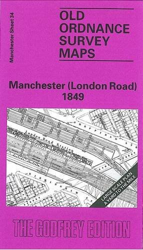
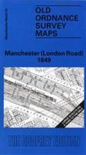
No Binding. Condition: New. No Jacket. Here are the details of maps for Manchester London Rd: Manchester Sheet 34 Manchester London Rd - published 1988; intro by Chris Makepeace. ISBN.978-0-85054-307-0 This extremely detailed map covers a busy area of south central Manchester, with coverage stretching from Brook Street eastward to Mayfield Street, and from Sheffield Street southward to Russell Street. The main feature is London Road (today Piccadilly) station shown in detail, plus a stretch of the Manchester South Junction & Altrincham Railway. Other features include Ardwick Bridge Chemical Works, River Medlock, Hanover Mill, Old Garratt Dye Works, New Garratt Print Works, St Augustine's RC church, Rochdale Canal, St George's Foundry, Banktop Canal Wharf, Charles Street Bridge, Grosvenor Street Chapel, Manchester & Buxton turnpike trust, London Road area, Mayfield Print Works, Ardwick Dye Works, Chapel Field Dye Works, St Thomas church etc. On the reverse we include an Inch to the Mile map for the central Manchester area c.1910, plus street directory entries for Brook Street, London Road and Travis Street. The map links up with Manchester Sheets 29 Manchester Piccadilly to the north, 33 Oxford Street to the west, 35 Upper Ardwick to the east and 39 Chorlton on Medlock to the south.
-
Makepeace, C: Manchester (London Road) 1849
Published by Alan Godfrey Maps, 1990
ISBN 10: 085054307XISBN 13: 9780850543070
Book
Karte/Landkarte. Condition: New.