Order Total (1 Item Items):
Shipping Destination:

Arrowsmith Aaron Family (53 results)
Skip to main search results
Product Type
- All Product Types
- Books
- Magazines & Periodicals
- Comics
- Sheet Music
- Art, Prints & Posters
- Photographs
- Maps (53)
-
Manuscripts &
Paper Collectibles
Condition
- All Conditions
- New
- Used
Binding
- All Bindings
- Hardcover
- Softcover
Collectible Attributes
- First Edition
- Signed
- Dust Jacket
- Seller-Supplied Images
- Not Printed On Demand
Seller Location
Seller Rating
-
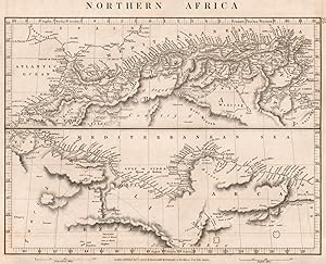
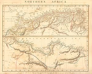
Condition: Good. NORTHERN AFRICA.Maghreb.Marocco Algiers Tunis Tripoli Barca.ARROWSMITH 1828 map. Antique copperplate map; A. Arrowsmith (1828). 26.0 x 32.0cm, 10.25 x 12.75 inches. Condition: Good. The image shown may have been taken from a different example of this map than that which is offered for sale. The map you will receive is in good condition but there may be minor variations in the condition from that shown in the image. There is nothing printed on the reverse side, which is plain.
-
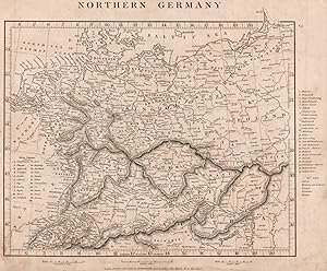
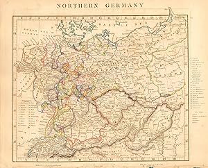
Condition: Good. NORTHERN GERMANY. States. Free Cities. Switzerland Austria. ARROWSMITH 1828 map. Antique copperplate map; A. Arrowsmith (1828). 25.5 x 31.0cm, 10 x 12.25 inches. Condition: Good. The image shown may have been taken from a different example of this map than that which is offered for sale. The map you will receive is in good condition but there may be minor variations in the condition from that shown in the image. There is nothing printed on the reverse side, which is plain.
-
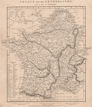
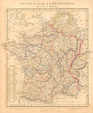
Condition: Good. FRANCE & BENELUX. Netherlands, with a part of Switzerland. ARROWSMITH 1828 map. Antique copperplate map; A. Arrowsmith (1828). 31.0 x 26.5cm, 12.25 x 10.5 inches. Condition: Good. The image shown may have been taken from a different example of this map than that which is offered for sale. The map you will receive is in good condition but there may be minor variations in the condition from that shown in the image. There is nothing printed on the reverse side, which is plain.
-
Condition: Good. NORTHERN AFRICA Maghreb Morocco Algiers Tunis Tripoli Barca. ARROWSMITH 1828 map. Antique copperplate map with original outline colour; A. Arrowsmith (1828). 26.0 x 32.0cm, 10.25 x 12.75 inches. Condition: Good. Tight bottom margin below caption; Minor offsetting -text and/or images from the facing page have left an impression on the print. Glue deposit to bottom margin. There is nothing printed on the reverse side, which is plain.
-
Condition: Good. FRANCE & the Netherlands with a part of Switzerland. Benelux ARROWSMITH 1828 map. Antique copperplate map with original outline colour; A. Arrowsmith (1828). 31.0 x 26.5cm, 12.25 x 10.5 inches. Condition: Good. Minor offsetting -text and/or images from the facing page have left an impression on the print. There is nothing printed on the reverse side, which is plain.
-
Condition: Good. NORTHERN GERMANY. States. Switzerland Austria Czechia. ARROWSMITH 1828 old map. Antique copperplate map with original outline colour; A. Arrowsmith (1828). 25.5 x 31.0cm, 10 x 12.25 inches. Condition: Good. Tight bottom margin below caption; Minor offsetting -text and/or images from the facing page have left an impression on the print. Damage to bottom margin, repaired. There is nothing printed on the reverse side, which is plain.
-
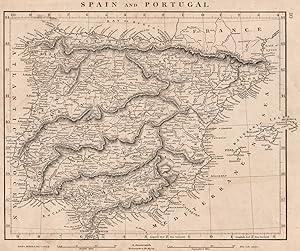
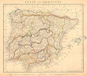
Condition: Good. IBERIA. Spain and Portugal General map. ARROWSMITH 1828 old antique chart. Antique copperplate map; A. Arrowsmith (1828). 24.5 x 29.5cm, 9.5 x 11.5 inches. Condition: Good. The image shown may have been taken from a different example of this map than that which is offered for sale. The map you will receive is in good condition but there may be minor variations in the condition from that shown in the image. There is nothing printed on the reverse side, which is plain.
-
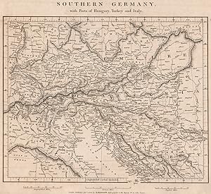
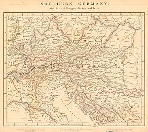
Condition: Good. CENT. EUROPE. Southern Germany. Parts Hungary Turkey Italy. ARROWSMITH 1828 map. Antique copperplate map; A. Arrowsmith (1828). 26.0 x 28.5cm, 10.25 x 11.25 inches. Condition: Good. The image shown may have been taken from a different example of this map than that which is offered for sale. The map you will receive is in good condition but there may be minor variations in the condition from that shown in the image. There is nothing printed on the reverse side, which is plain.
-
Condition: Good. EUROPE. Italian & German states. Original outline colour. ARROWSMITH 1828 map. Antique copperplate map with original outline colour; A. Arrowsmith (1828). 25.5 x 32.0cm, 10 x 12.5 inches. Condition: Good. Tight bottom margin below caption; Minor offsetting -text and/or images from the facing page have left an impression on the print. Pinholes in bottom margin. There is nothing printed on the reverse side, which is plain.
-
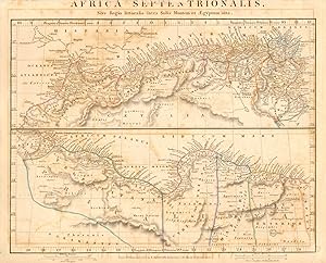
Africa Septentrionalis Sive Regio littoralis intra Solis Montem et Aegyptum sita
Publication Date: 1828
Map
Condition: Good. ANCIENT NORTH AFRICA Septentrionalis. Mauretania Tripolitana ARROWSMITH 1828 map. Antique copperplate map with original outline colour; A. Arrowsmith (1828). 26.5 x 32.0cm, 10.5 x 12.5 inches. Condition: Good. Tight bottom margin below caption; Tight top margin; Minor offsetting -text and/or images from the facing page have left an impression on the print. Glue deposit to top margin/title. There is nothing printed on the reverse side, which is plain.
-
Condition: Good. IBERIA. Spain and Portugal General map. Provinces. ARROWSMITH 1828 old. Antique copperplate map with original outline colour; A. Arrowsmith (1828). 24.5 x 29.5cm, 9.5 x 11.5 inches. Condition: Good. Spot in margin; Minor offsetting -text and/or images from the facing page have left an impression on the print. There is nothing printed on the reverse side, which is plain.
-
Condition: Good. SOUTHERN GERMANY with parts of Hungary Turkey Italy. Austria ARROWSMITH 1828 map. Antique copperplate map with original outline colour; A. Arrowsmith (1828). 26.0 x 28.5cm, 10.25 x 11.25 inches. Condition: Good. Tight bottom margin below caption; Minor offsetting -text and/or images from the facing page have left an impression on the print. Damage to bottom margin, repaired. There is nothing printed on the reverse side, which is plain.
-
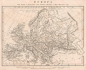
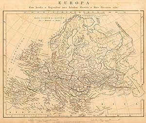
Europa; Cum Insulis et Regionibus intra Paludem Maeotida et Mare Hyrcanum sitis
Publication Date: 1828
Map
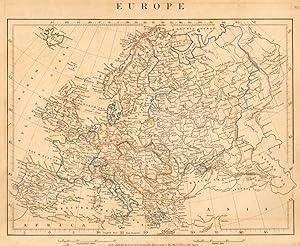
Condition: Good. EUROPE ANCIENT.Europa.Germania Gallia Hispania Sarmatia &c.ARROWSMITH 1828 map. Antique copperplate map; A. Arrowsmith (1828). 26.0 x 32.0cm, 10.25 x 12.5 inches. Condition: Good. The image shown may have been taken from a different example of this map than that which is offered for sale. The map you will receive is in good condition but there may be minor variations in the condition from that shown in the image. There is nothing printed on the reverse side, which is plain.
-
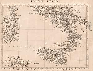
Condition: Good. ITALY SOUTH. General map. Sardinia Sicily. ARROWSMITH 1828 old antique. Antique copperplate map; A. Arrowsmith (1828). 25.5 x 33.5cm, 10 x 13.25 inches. Condition: Good. The image shown may have been taken from a different example of this map than that which is offered for sale. The map you will receive is in good condition but there may be minor variations in the condition from that shown in the image. There is nothing printed on the reverse side, which is plain.
-
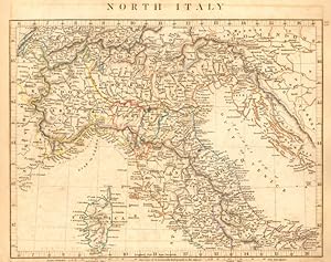
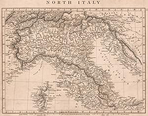
Condition: Good. NORTHERN ITALY. Sardinia Lombardy Tuscany Papal States. ARROWSMITH 1828 map. Antique copperplate map with original outline colour; A. Arrowsmith (1828). 24.5 x 31.0cm, 9.5 x 12.25 inches. Condition: Good. However, please note: Tight bottom margin below caption; Minor offsetting -text and/or images from the facing page have left an impression on the print. There is nothing printed on the reverse side, which is plain.
-
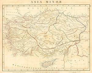
Condition: Good. ASIA MINOR. Turkey. Anadolia Karamania Anatolia. ARROWSMITH 1828 old map. Antique copperplate map with original outline colour; A. Arrowsmith (1828). 25.5 x 32.5cm, 10 x 12.75 inches. Condition: Good. Tight top margin; Minor offsetting -text and/or images from the facing page have left an impression on the print. There is nothing printed on the reverse side, which is plain.
-
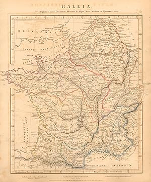
Gallia vel Regiones intra Oceanum, Rhenum f1. Alpes, Mare Medium et Pyrenaeos sitae
Publication Date: 1828
Map
Condition: Good. ANCIENT ROMAN FRANCE GAUL. Gallia France Lugdunensis. ARROWSMITH 1828 old map. Antique copperplate map with original outline colour; A. Arrowsmith (1828). 31.0 x 27.0cm, 12.25 x 10.5 inches. Condition: Good. Minor offsetting -text and/or images from the facing page have left an impression on the print. There is nothing printed on the reverse side, which is plain.
-
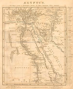
Aegyptus vel Regio, quam a Tachompso Insula ad Mare Internum Nilus interluit
Publication Date: 1828
Map
Condition: Good. ANCIENT EGYPT. Aegyptus Thebais Arcadia Heptanomis. ARROWSMITH 1828 old map. Antique copperplate map with original outline colour; A. Arrowsmith (1828). 31.0 x 25.5cm, 12.25 x 10 inches. Condition: Good. Minor offsetting -text and/or images from the facing page have left an impression on the print. Tear across bottom right corner, repaired verso. There is nothing printed on the reverse side, which is plain.
-
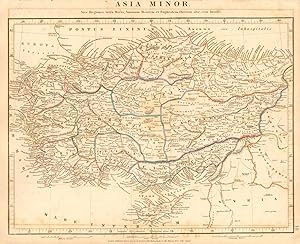
Asia Minor, Sive Regiones intra Maria, Amanum Montem et Euphratem fluvium sitae, cum Insulis
Publication Date: 1828
Map
Condition: Good. ANCIENT ASIA MINOR. Galatia Cappadocia Phrygia Bithynia. ARROWSMITH 1828 map. Antique copperplate map with original outline colour; A. Arrowsmith (1828). 26.0 x 32.5cm, 10.25 x 12.75 inches. Condition: Good. Minor offsetting -text and/or images from the facing page have left an impression on the print. There is nothing printed on the reverse side, which is plain.
-
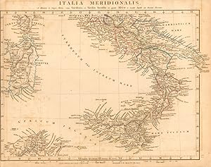
Italia Meridionalis A Minione et sagro fluviis, cum Sardinia et Sicilia Insulis et parte Africae a Monte Aspide ad Tuscam fluvium
Publication Date: 1828
Map
Condition: Good. ANCIENT ROMAN ITALY SOUTH. Italia Meridionalis. Sicilia. ARROWSMITH 1828 map. Antique copperplate map with original outline colour; A. Arrowsmith (1828). 26.0 x 34.0cm, 10.25 x 13.25 inches. Condition: Good. Minor offsetting -text and/or images from the facing page have left an impression on the print. No left margin (image incomplete: a small part of the print may be missing compared to that shown in the scan); The map was printed without a left margin, which has been restored. There is nothing printed on the reverse side, which is plain.
-
Europa cum Insulis et Regionibus intra Paludem Maeotida et Mare Hyrcanum sitis
Publication Date: 1828
Map
Condition: Good. ANCIENT ROMAN EUROPE. Europa. Germania Gallia Hispania. ARROWSMITH 1828 map. Antique copperplate map with original outline colour; A. Arrowsmith (1828). 26.0 x 32.0cm, 10.25 x 12.5 inches. Condition: Good. Minor offsetting -text and/or images from the facing page have left an impression on the print. Areas of surface paper damage to top right and bottom left margins. There is nothing printed on the reverse side, which is plain.
-
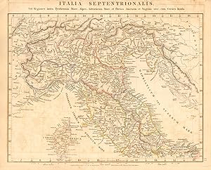
Italia Septentrionalis vel regiones intra Tyrrhenum Mare, Alpes, Adriaticum Mare, et fluvios Anienem et Sagrum sitae, cum Corsica Insula
Publication Date: 1828
Map
Condition: Good. ANCIENT ROMAN NORTHERN ITALY. Italia Septentrionalis. Gallia Cisalpina 1828 map. Antique copperplate map with original outline colour; A. Arrowsmith (1828). 25.0 x 31.0cm, 9.75 x 12 inches. Condition: Good. Minor offsetting -text and/or images from the facing page have left an impression on the print. There is nothing printed on the reverse side, which is plain.
-
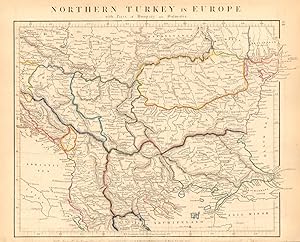
Condition: Good. BALKANS. Northern Turkey In Europe. Rumilia Wallachia. ARROWSMITH 1828 old map. Antique copperplate map with original outline colour; A. Arrowsmith (1828). 25.5 x 31.5cm, 10 x 12.25 inches. Condition: Good. Tight bottom margin below caption; Minor offsetting -text and/or images from the facing page have left an impression on the print. The scale in the bottom margin has been trimmed. There is nothing printed on the reverse side, which is plain.
-
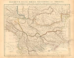
Illyricum, Dacia, Mcesia, Macedonia et Thracia vel Regiones circa Danubium f1. et a Danubio f1. usque ad Aegaeum Mare et Montes Ceraunios et Cambunios sitae
Publication Date: 1828
Map
Condition: Good. ANCIENT ROMAN BALKANS. Illyricum Dacia Moesia Macedonia. ARROWSMITH 1828 map. Antique copperplate map with original outline colour; A. Arrowsmith (1828). 25.5 x 31.5cm, 10 x 12.25 inches. Condition: Good. Tight bottom margin below caption; Minor offsetting -text and/or images from the facing page have left an impression on the print. There is nothing printed on the reverse side, which is plain.
-
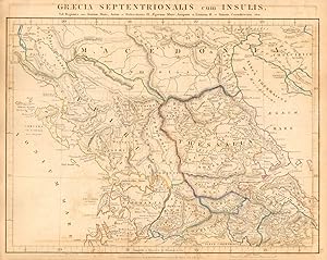
Graecia Septentrionalis cum Insulis vel Regiones intra Ionium Mare, Aoum et Haliacmona f1. Aegaeum Mare, Asopum et Lamum f1. et Sinum Corinthiacum sitae
Publication Date: 1828
Map
Condition: Good. GRAECIA SEPTENTRIONALIS. Ancient Northern Greece. ARROWSMITH 1828 old map. Antique copperplate map with original outline colour; A. Arrowsmith (1828). 26.5 x 32.5cm, 10.25 x 12.75 inches. Condition: Good. Tight bottom margin below caption; Minor offsetting -text and/or images from the facing page have left an impression on the print. The scale in the bottom margin has been trimmed. There is nothing printed on the reverse side, which is plain.
-
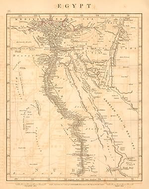
Condition: Good. EGYPT & Nubia. Nile Valley. Red Sea. Bahri Vostani Sinai. ARROWSMITH 1828 map. Antique copperplate map with original outline colour; A. Arrowsmith (1828). 30.5 x 23.5cm, 12 x 9.25 inches. Condition: Good. Minor offsetting -text and/or images from the facing page have left an impression on the print. There is nothing printed on the reverse side, which is plain.
-
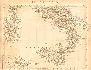
Condition: Good. SOUTHERN ITALY. Naples Sardinia Sicily. ARROWSMITH 1828 old antique map chart. Antique copperplate map with original outline colour; A. Arrowsmith (1828). 25.5 x 33.5cm, 10 x 13.25 inches. Condition: Good. Minor offsetting -text and/or images from the facing page have left an impression on the print. The scale in the bottom margin has been trimmed. There is nothing printed on the reverse side, which is plain.
-
Condition: Good. NORTHERN ITALY. Papal States. Sardinia Lombardy Tuscany. ARROWSMITH 1828 map. Antique copperplate map; A. Arrowsmith (1828). 24.5 x 31.0cm, 9.5 x 12.25 inches. Condition: Good. The image shown may have been taken from a different example of this map than that which is offered for sale. The map you will receive is in good condition but there may be minor variations in the condition from that shown in the image. There is nothing printed on the reverse side, which is plain.
-
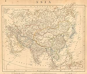
Condition: Good. ASIA Hindoostan Arabia Persia Tataria Birman Empire China. ARROWSMITH 1828 map. Antique copperplate map with original outline colour; A. Arrowsmith (1828). 26.0 x 31.5cm, 10.25 x 12.5 inches. Condition: Good. Tight bottom margin below caption; Spot in margin; Minor offsetting -text and/or images from the facing page have left an impression on the print. There is nothing printed on the reverse side, which is plain.
-
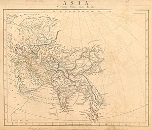
Condition: Good. ASIA ANCIENT Middle East India Arabia Scythia Serica Parthia ARROWSMITH 1828 map. Antique copperplate map with original outline colour; A. Arrowsmith (1828). 26.0 x 32.0cm, 10.25 x 12.5 inches. Condition: Good. Tight bottom margin below caption; Blemish in margin; Spot in margin; Minor offsetting -text and/or images from the facing page have left an impression on the print. There is nothing printed on the reverse side, which is plain.