Order Total (1 Item Items):
Shipping Destination:

Chapman, Silas: Wisconsin (2 results)
Skip to main search results
Product Type
- All Product Types
- Books (2)
- Magazines & Periodicals
- Comics
- Sheet Music
- Art, Prints & Posters
- Photographs
- Maps
-
Manuscripts &
Paper Collectibles
Condition
- All Conditions
- New
- Used
Binding
- All Bindings
- Hardcover
- Softcover
Collectible Attributes
- First Edition (1)
- Signed
- Dust Jacket
- Seller-Supplied Images (1)
- Not Printed On Demand
Seller Location
Seller Rating
-
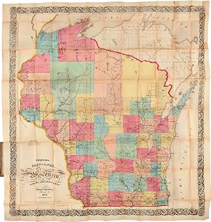
CHAPMAN'S SECTIONAL MAP OF WISCONSIN, WITH THE MOST RECENT SURVEYS
Published by Milwaukee, 1856
Seller: William Reese Company - Americana, New Haven, CT, U.S.A.
Association Member: ABAA ESA ILAB SNEAB
Seller Rating:

Folding map, 36 x 33 1/2 inches, with full period hand-coloring. In original 16mo. cloth, stamped in blind and gilt. Cloth a touch faded. Near fine. A large, attractive map of Wisconsin, showing all the surveyed counties and many towns, and extending northward to include the unsurveyed areas. Chapman produced several pocket maps of Wisconsin, Minnesota, and Iowa. This version was copyrighted the previous year and is unrecorded in this configuration by Phillips. RUMSEY 1661. CHECKLIST OF PRINTED MAPS OF THE MIDDLE WEST TO 1900 (WISCONSIN), p.303.
-

A hand book of Wisconsin; or guilde to travellers & immigrants; designed as an accompaniment to Chapman's map of Wisconsin. (together with) Chapman's sectional map of Wisconsin with the most recent surveys, 1855
Published by Silas Chapman, Milwaukee, WI, 1855
Seller: B & L Rootenberg Rare Books, ABAA, Sherman Oaks, CA, U.S.A.
Seller Rating:

First Edition
FIRST EDITION. Hand-coloured outlines. Original plain green cloth boards. Folding map in brown cloth folder with gilt title on cover; book dampstained and toned, map has dampstaining with loss of paper but mainly to blank portions and a little at the upper left corner; many other small splits at folding points. Folder is worn and rubbed. First edition of the book and of the map, which is quite scarce. Each county is hand-oulined in red and the entire state is outlined in blue and shows towns, roads and railroads, both completed and in progress. This is the first Chapman map of Wisconsin together with the first printing of its companion guide book. Neither have appeared at auction in the last thirty years and are very elusive in any condition.