Michelin Map USA Political 14761 (p, Rolled) (Maps/Wall (Michelin))
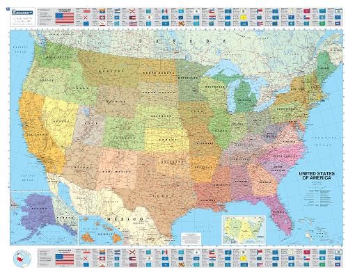

An annually updated political map of the USA. Beautifully colored. Rolled and tubed, with statistical information including population, surface area, state capital, (40" x 50"). Highlights the flags of each state. Scale: 1/3,850,000 - 1cm = 38.5km - 1in = 55 miles. Legend/Key in three languages (English, French, Spanish)
"synopsis" may belong to another edition of this title.
- PublisherMichelin
- Publication date2017
- ISBN 10 2061011306
- ISBN 13 9782061011300
- BindingMap
- Number of pages1
Buy New
Learn more about this copy
US$ 15.21
Shipping:
FREE
Within U.S.A.
Top Search Results from the AbeBooks Marketplace
Seller Image
Michelin Map USA Political 14761 (P, Rolled) (Not Folded)
Published by
Michelin Travel Publications, Paris
(2003)
ISBN 10: 2061011306
ISBN 13: 9782061011300
New
Quantity: 1
Seller:
Rating
Book Description Not Folded. Condition: new. Not Folded. An annually updated political map of the USA. Beautifully colored. Rolled and tubed, with statistical information including population, surface area, state capital, (40 x 50). Highlights the flags of each state. Scale: 1/3,850,000 - 1cm = 38.5km - 1in = 55 miles. Legend/Key in three languages (English, French, Spanish) An annually updated political map of the USA. Beautifully colored. Rolled and tubed, with statistical information including population, surface area, state capital, (40 x 50). Highlights the flags of each state. Scale: 1/3,850,000 - 1cm = 38.5km - 1in = 55 miles. Legend/Key in three languages (English, French, Spanish) Shipping may be from multiple locations in the US or from the UK, depending on stock availability. Seller Inventory # 9782061011300
Buy New
US$ 15.21
Convert currency
Stock Image
Michelin Map USA Political 14761 (p, Rolled) (Michelin Wall Maps)
Published by
Michelin Travel Publications
(2017)
ISBN 10: 2061011306
ISBN 13: 9782061011300
New
Quantity: 3
Seller:
Rating
Book Description Condition: New. Seller Inventory # 6514329
Buy New
US$ 18.01
Convert currency
Stock Image
Michelin Map USA Political 14761 (p, Rolled) (Maps/Wall (Michelin))
Seller:
Rating
Book Description Condition: new. Seller Inventory # 6U4IPIA71I
Buy New
US$ 22.01
Convert currency
Stock Image
Michelin Map USA Political 14761 (p, Rolled) (Maps/Wall (Michelin))
Published by
Michelin Travel Partner
(2017)
ISBN 10: 2061011306
ISBN 13: 9782061011300
New
Quantity: > 20
Seller:
Rating
Book Description Condition: New. 2003. 2017th Edition. Map. Series: Michelin Wall Maps. Num Pages: colour mapping. BIC Classification: 1KBB; WTRM. Category: (G) General (US: Trade). Dimension: 999 x 60 x 50. Weight in Grams: 221. . . . . . Books ship from the US and Ireland. Seller Inventory # V9782061011300
Buy New
US$ 29.53
Convert currency
Stock Image
Michelin Map USA Political 14761 (p, Rolled) (Maps/Wall (Michelin))
Seller:
Rating
Book Description Map. Condition: New. Brand New!. Seller Inventory # VIB2061011306
Buy New
US$ 47.47
Convert currency
Stock Image
Michelin Map USA Political 14761 (p, Rolled) (Maps/Wall (Michelin))
Published by
Michelin Travel Partner
(2003)
ISBN 10: 2061011306
ISBN 13: 9782061011300
New
Quantity: > 20
Seller:
Rating
Book Description Condition: New. 2003. 2017th Edition. Map. Series: Michelin Wall Maps. Num Pages: colour mapping. BIC Classification: 1KBB; WTRM. Category: (G) General (US: Trade). Dimension: 999 x 60 x 50. Weight in Grams: 221. . . . . . Seller Inventory # V9782061011300
Buy New
US$ 36.19
Convert currency
Stock Image
USA Political Wall Maps
Published by
Michelin Editions des Voyages
(2017)
ISBN 10: 2061011306
ISBN 13: 9782061011300
New
Quantity: 1
Seller:
Rating
Book Description Condition: new. Book is in NEW condition. Satisfaction Guaranteed! Fast Customer Service!!. Seller Inventory # PSN2061011306
Buy New
US$ 21.94
Convert currency
Seller Image
Michelin Map USA Political 14761 (P, Rolled) (Not Folded)
Published by
Michelin Travel Publications, Paris
(2003)
ISBN 10: 2061011306
ISBN 13: 9782061011300
New
Quantity: 1
Seller:
Rating
Book Description Not Folded. Condition: new. Not Folded. An annually updated political map of the USA. Beautifully colored. Rolled and tubed, with statistical information including population, surface area, state capital, (40 x 50). Highlights the flags of each state. Scale: 1/3,850,000 - 1cm = 38.5km - 1in = 55 miles. Legend/Key in three languages (English, French, Spanish) An annually updated political map of the USA. Beautifully colored. Rolled and tubed, with statistical information including population, surface area, state capital, (40 x 50). Highlights the flags of each state. Scale: 1/3,850,000 - 1cm = 38.5km - 1in = 55 miles. Legend/Key in three languages (English, French, Spanish) Shipping may be from our Sydney, NSW warehouse or from our UK or US warehouse, depending on stock availability. Seller Inventory # 9782061011300
Buy New
US$ 18.43
Convert currency
Seller Image
Michelin Map USA Political 14761 (P, Rolled) (Not Folded)
Published by
Michelin Travel Publications, Paris
(2003)
ISBN 10: 2061011306
ISBN 13: 9782061011300
New
Quantity: 1
Seller:
Rating
Book Description Not Folded. Condition: new. Not Folded. An annually updated political map of the USA. Beautifully colored. Rolled and tubed, with statistical information including population, surface area, state capital, (40 x 50). Highlights the flags of each state. Scale: 1/3,850,000 - 1cm = 38.5km - 1in = 55 miles. Legend/Key in three languages (English, French, Spanish) An annually updated political map of the USA. Beautifully colored. Rolled and tubed, with statistical information including population, surface area, state capital, (40 x 50). Highlights the flags of each state. Scale: 1/3,850,000 - 1cm = 38.5km - 1in = 55 miles. Legend/Key in three languages (English, French, Spanish) Shipping may be from our UK warehouse or from our Australian or US warehouses, depending on stock availability. Seller Inventory # 9782061011300
Buy New
US$ 18.30
Convert currency