Central Birmingham 1888: Warwickshire Sheet 14.05a (Old Ordnance Survey Maps of Warwickshire)
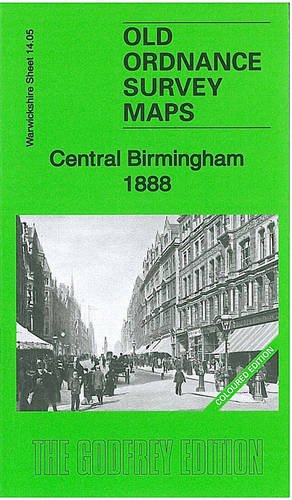

Warwickshire Sheet 14.05a Central Birmingham 1888 - published 2011; intro by Barrie Trinder. Covers the heart of Birmingham, showing how the area changed across the years. Coverage stretches from Summer Row eastward to Watery Lane, and from Prospect Row southward to Moseley Street. Market Hall Ward and St Bartholomew's Ward are included. The many features include New Street station, Snow Hill station, Curzon Street Goods station, tramways, General Hospital, Smithfield Market, Midland Railway Goods Depot, St Philip's church, Old Wharf Basin, Town Hall, Central Library, St Mary's church, St Thomas church, Bordesley station, Warwick & Birmingham Canal, Banbury Street Wharf, Deritend, St Martin's church, St Bartholomew's church, Lawley Street Goods station (at edge of map), St Paul's church, many small factories and workshops (eg Looking Glass Manufactory, Carriage Works, Vinegar Brewery etc), streets packed with terraces, back-to-back houses etc. On the reverse of each map we include extracts from a 1907 street directory. The 1888 version is Colour-printed, representing the beautiful handcolouring of some 1st Edition OS maps.
"synopsis" may belong to another edition of this title.
- PublisherGARDNERS VI BOOKS AMS006
- Publication date1800
- ISBN 10 1847844928
- ISBN 13 9781847844927
- BindingMap
Buy New
Learn more about this copy
US$ 8.96
Shipping:
FREE
Within U.S.A.
Top Search Results from the AbeBooks Marketplace
Seller Image
Central Birmingham 1888: Warwickshire Sheet 14.05a (Old Ordnance Survey Maps of Warwickshire) [No Binding ]
Published by
Alan Godfrey Maps
(2011)
ISBN 10: 1847844928
ISBN 13: 9781847844927
New
No Binding
Quantity: 1
Seller:
Rating
Book Description No Binding. Condition: new. Seller Inventory # 9781847844927
Buy New
US$ 8.96
Convert currency