Longton (West) 1898: Staffordshire Sheet 18.10 (Old O.S. Maps of Staffordshire)

Buy New
Learn more about this copy
US$ 4.84
Shipping:
US$ 38.18
From United Kingdom to U.S.A.
Top Search Results from the AbeBooks Marketplace
Stock Image
Longton (West) 1898: Staffordshire Sheet 18.10 (Old O.S. Maps of Staffordshire) O/S
Seller:
Rating
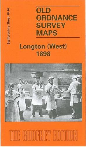
Book Description No Binding. Condition: New. No Jacket. Here are the details of maps for Longton (West): Staffordshire Sheet 18.10 Longton (West) 1898 - published 1999; intro by Alan Godfrey. ISBN.978-1-84151-044-6 Part of our extensive coverage of The Potteries, this detailed map covers the western part of Longton, including the Dresden area. Coverage stretches from Vauxhall Street and Rosslyn Road westward to Longton Mill, and from Longton station southward to Queens Park. Features include Cemetery, Dresden area with streets of small terraces, Blurton Green Farm, St Paul's church, Town Hall, tramways, potteries and earthenware manufactories, Longton Hall Colliery, Longton Hall, Swingle Hill, disused iron works, mineral lines, Blurton Tileries, Hollybush Farm etc. On the reverse we include directory extracts including a Dresden & Florence Alphabetical List for 1892-3. The map links up with sheets 18.06 A HREF="staffs1806.htm">Fenton to the north, 18.09 Trent Vale to the west and 18.11 Longton East to the east. Seller Inventory # 008599
Buy New
US$ 4.84
Convert currency