Tipton 1884: Staffordshire Sheet 67.08a (Old Ordnance Survey Maps of Staffordshire)

Buy New
Learn more about this copy
US$ 3.95
Shipping:
US$ 39.01
From United Kingdom to U.S.A.
Top Search Results from the AbeBooks Marketplace
Stock Image
Tipton 1884: Staffordshire Sheet 67.08a (Old Ordnance Survey Maps of Staffordshire)
Seller:
Rating
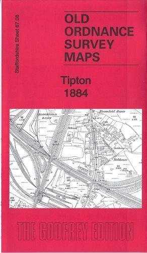
Book Description No Binding. Condition: New. Dust Jacket Condition: New. Here are the details of maps for Tipton & Bloomfield: Staffs 67.08a Tipton 1884 - published 2018; intro by Angus Dunphy. ISBN.978-1-78721-148-3 Staffs 67.08b Tipton 1904 - published 1989; intro by Robin Pearson. ISBN.978-0-85054-225-7 Staffs 67.08c Tipton 1914 - published 2017; intro by Barrie Trinder. ISBN.978-1-78721-104-9 We have published thee versions of this map, showing how the area changed across the years. They cover a busy industrial area that includes Bloomfield, Princes End, much of central Tipton, Summer Hill and the southern tip of Coseley. Features include Birningham Canal, Wolverhampton Level and Birmingham Level; tramways, LNWR Stour Valley Line with Tipton station, GWR Oxford Worcester & Wolverhampton line with Princes End and Tipton stations; Tipton Green Blast Furnaces, Moat Foundry, Tipton Engineering Works, Adelaide Tube Works, Moat Colliery, Horseley Colliery, Tibbington Collieries, Empire Colliery, Lloyd's Proving House, Foxyards Fire Brick Works, Foxyards Colliery, many disused collieries and coal shafts, canal basins, old industrial landscape. The map links up with Staffordshire sheets 67.04 Bradley to the north, 67.07 Sedgley SE to the west, 68.05 Great Bridge to the east, 67.12 Dudley Castle to the south. Seller Inventory # 008680
Buy New
US$ 3.95
Convert currency