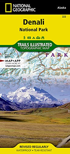
Denali National Park and Preserve Map (National Geographic Trails Illustrated Map, 222)

� Waterproof � Tear-Resistant � Topographic Map
Denali National Park and Preserve covers a staggering six million acres of truly wild and pristine wilderness, bisected by a single road. The crown jewel of the park is the towering 20,320 foot Mount McKinley, North America's tallest peak. Expertly researched and created in partnership with local land management agencies, National Geographic's Trails Illustrated map of Denali National Park provides an unparalleled tool for exploring this remarkable region. Key areas of interest featured on this map include Denali State Park; Kroto, Moose Creek, and Lake Creek recreation rivers; Lake Minchumina; and the Kantishna Mining District. The print version of the map includes a detailed inset of the park entrance and headquarters.
If you wish to camp in the park, a chart of campground information that includes the distance from the entrance, number and type of spaces, facilities, access, and contact information for making your reservations will help you plan your stay. Private vehicle travel in the park is limited, but this map's coverage of the shuttle bus system will ensure you have the knowledge you need to access the entire park. Helpful information about regulations, avoiding close encounters with bears, hiking in the Kantishna Mining District, and safety tips, as well as clearly marked campgrounds, rental cabins, bush airstrips, trailheads, and more will help you enjoy all the park has to offer. The map base includes contour lines and elevations for summits, passes and many lakes.
Every Trails Illustrated map is printed on "Backcountry Tough" waterproof, tear-resistant paper. A full UTM grid is printed on the map to aid with GPS navigation.
Other features found on this map include: Bear Creek, Birch Creek, Broad Pass, Browne Tower, Chelatna Lake, Chulitna River, Chunilna Creek, Dall Glacier, Denali National Park, Denali National Preserve, East Buttress, Eldridge Glacier, Foraker River, Herron River, Kahiltna Glacier, Lacuna Glacier, Lake Minchumina, McKinley River, Moose Creek, Mount Foraker, Mount Hunter, Mount Mather, Mount McKinley, Muldrow Glacier, Portage Creek, Ruth Glacier, Sheep River, South Buttress, Stephan Lake, Talkeetna River, Tokositna Glacier, Yanert Fork, Yentna Glacier.
- Map Scale = 1:225,000
- Sheet Size = 25.5" x 37.75"
- Folded Size = 4.25" x 9.25"
"synopsis" may belong to another edition of this title.
About the Author:
Founded in 1915 as the Cartographic Group, the first division of National Geographic, National Geographic Maps has been responsible for illustrating the world around us through the art and science of mapmaking.Today, National Geographic Maps continues this mission by creating the world's best wall maps, recreation maps, atlases, and globes which inspire people to care about and explore their world.
"About this title" may belong to another edition of this title.
- PublisherNational Geographic Maps
- Publication date2023
- ISBN 10 1566953286
- ISBN 13 9781566953283
- BindingMap
- Number of pages2
- Rating
Buy New
Learn more about this copy
US$ 15.35
Shipping:
FREE
Within U.S.A.
Top Search Results from the AbeBooks Marketplace
Stock Image
Denali National Park and Preserve Map (National Geographic Trails Illustrated Map, 222)
Published by
National Geographic Maps
(2023)
ISBN 10: 1566953286
ISBN 13: 9781566953283
New
Quantity: 1
Seller:
Rating
Book Description Condition: New. Book is in NEW condition. Seller Inventory # 1566953286-2-1
Buy New
US$ 15.35
Convert currency
Stock Image
Denali National Park and Preserve Map (National Geographic Trails Illustrated Map, 222)
Published by
National Geographic Maps
(2023)
ISBN 10: 1566953286
ISBN 13: 9781566953283
New
Quantity: 1
Seller:
Rating
Book Description Condition: New. New! This book is in the same immaculate condition as when it was published. Seller Inventory # 353-1566953286-new
Buy New
US$ 15.36
Convert currency
Stock Image
Denali National Park and Preserve, AK - Trails Illustrated Map #222
Published by
National Geographic Maps
(2007)
ISBN 10: 1566953286
ISBN 13: 9781566953283
New
Quantity: 1
Seller:
Rating
Book Description Map. Condition: New. 3. Seller Inventory # DADAX1566953286
Buy New
US$ 15.39
Convert currency
Stock Image
Denali National Park and Preserve (National Geographic Trails Illustrated Map)
Published by
National Geographic Maps
(2023)
ISBN 10: 1566953286
ISBN 13: 9781566953283
New
Quantity: 7
Seller:
Rating
Book Description Condition: New. Brand New! Not Overstocks or Low Quality Book Club Editions! Direct From the Publisher! We're not a giant, faceless warehouse organization! We're a small town bookstore that loves books and loves it's customers! Buy from Lakeside Books!. Seller Inventory # OTF-S-9781566953283
Buy New
US$ 12.55
Convert currency
Stock Image
Denali National Park and Preserve Map (National Geographic Trails Illustrated Map, 222)
Published by
National Geographic Maps
(2023)
ISBN 10: 1566953286
ISBN 13: 9781566953283
New
Quantity: 12
Seller:
Rating
Book Description Condition: New. Seller Inventory # I-9781566953283
Buy New
US$ 19.00
Convert currency
Stock Image
Denali National Park And Preserve
Published by
National Geographic Maps Division 2012-08-02, Washington, D.C.
(2012)
ISBN 10: 1566953286
ISBN 13: 9781566953283
New
Quantity: 1
Seller:
Rating
Book Description sheet map (folded). Condition: New. Language: ENG. Seller Inventory # 9781566953283
Buy New
US$ 16.71
Convert currency
Stock Image
Denali National Park GPS Alaska NGNP222 Trails Illustrated National Parks National Geographic Trails Illustrated Map
Published by
National Geographic Maps Division
(2012)
ISBN 10: 1566953286
ISBN 13: 9781566953283
New
Quantity: 1
Seller:
Rating
Book Description UNK. Condition: New. New Book. Shipped from UK. Established seller since 2000. Seller Inventory # EA-9781566953283
Buy New
US$ 23.90
Convert currency
Stock Image
Denali National Park and Preserve (National Geographic Trails Illustrated Map (222))
Published by
National Geographic Maps
(2019)
ISBN 10: 1566953286
ISBN 13: 9781566953283
New
Quantity: 11
Seller:
Rating
Book Description Map. Condition: New. 2019th Edition. Special order direct from the distributor. Seller Inventory # ING9781566953283
Buy New
US$ 14.95
Convert currency
Stock Image
Denali National Park and Preserve Map (National Geographic Trails Illustrated Map, 222)
Published by
National Geographic Maps
(2023)
ISBN 10: 1566953286
ISBN 13: 9781566953283
New
Paperback
Quantity: 1
Seller:
Rating
Book Description Paperback. Condition: new. New. Fast Shipping and good customer service. Seller Inventory # Holz_New_1566953286
Buy New
US$ 22.85
Convert currency
Stock Image
Denali National Park and Preserve Map (National Geographic Trails Illustrated Map, 222)
Published by
National Geographic Maps
(2023)
ISBN 10: 1566953286
ISBN 13: 9781566953283
New
Paperback
Quantity: 1
Seller:
Rating
Book Description Paperback. Condition: new. Buy for Great customer experience. Seller Inventory # GoldenDragon1566953286
Buy New
US$ 23.73
Convert currency