Ettingshall 1901: Staffordshire Sheet 62.15 (Old O.S. Maps of Staffordshire) - Softcover

- PublisherAlan Godfrey Maps
- Publication date1996
- ISBN 10 0850547989
- ISBN 13 9780850547986
- BindingPaperback
Buy New
Learn more about this copy
US$ 43.73
Shipping:
FREE
Within U.S.A.
Top Search Results from the AbeBooks Marketplace
Stock Image
Ettingshall 1901: Staffordshire Sheet 62.15 (Old O.S. Maps of Staffordshire)
Published by
Alan Godfrey Maps
(1996)
ISBN 10: 0850547989
ISBN 13: 9780850547986
New
Softcover
Quantity: 1
Seller:
Rating
Book Description Condition: New. Book is in NEW condition. 4. Seller Inventory # 0850547989-2-1
Buy New
US$ 43.73
Convert currency
Stock Image
Ettingshall 1901: Staffordshire Sheet 62.15 (Old O.S. Maps of Staffordshire)
Published by
Alan Godfrey Maps
(1996)
ISBN 10: 0850547989
ISBN 13: 9780850547986
New
Softcover
Quantity: 1
Seller:
Rating
Book Description Condition: New. New! This book is in the same immaculate condition as when it was published 4. Seller Inventory # 353-0850547989-new
Buy New
US$ 43.74
Convert currency
Stock Image
Ettingshall 1901: Staffordshire Sheet 62.15 (Old O.S. Maps of Staffordshire)
Seller:
Rating
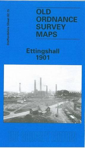
Book Description No Binding. Condition: New. Here are details of the map for Ettingshall: Staffordshire Sheet 62.15 Ettingshall 1901 - published 1996; intro by John Boynton. ISBN.978-0-85054-798-6 This detailed map covers the Ettingshall area, SE of Wolverhampton, and also includes Millfields, Parkfield and Spring Vale. Features include LNWR Stour Valley line with Ettingshall Road station, Ettingshall Colliery, Ettingshall Park Colliery, Park Hill, Sedgley Park Colliery (disused), Cockshutts Colliery, Parkfield Colliery, brick works, old mine shafts, Lanesfield, Lanesfield Colliery, Manor Iron & Steel Works, Staffordshire Steel & Ingot Iron Works, Spring Vale Furnaces, Ettingshall Lodge Colliery, Millfield Works, Bilston Gas Works, Freezelands, short stretch of GWR railway with Priestfield station, New Village, Mars Iron Works, Birmingham Canal (Wolverhampton Level), Rough Hills, Holy Trinity church, Bilston Flour Mill, Springvale Foundry, tramway, etc. On the reverse we include a directory of Ettingshall plus an extract from a LNWR timetable for the Stafford-Birmingham line. The map links up with Staffordshire sheets 62.11 Wolverhampton SE to the north, 62.14 Upper Penn to the west, 62.16 Bilston to the east, 67.03 Sedgley NE to the south. Seller Inventory # 000035
Buy New
US$ 4.92
Convert currency